

Rain returned to much of the UK on 18 August 2026 for the first time in roughly two months, ending an unusually long dry spell and pushing temperatures down by around 2 to 4C below the mid-August average for the rest of the week. Despite this cooler, wetter turn, long-range forecasts are already pointing to the possibility of a sixth heatwave of the year developing in September once the wet spell clears.
The shift in conditions has prompted questions about whether the exceptional heat that has defined summer 2026 is truly over, or whether one more hot spell is waiting in the wings before autumn takes hold.
How hot has this summer really been?
The Met Office says 2026 is on course to be the UK's hottest summer on record, and forecasters covering the story earlier this month described the season as still "heading for" that record even before the most recent heat surge. According to a live coverage from a national newspaper, meteorological summer 2026 is now widely regarded as on track to be the hottest on record following the late-August heat surge. For the record to be avoided, average temperatures across the final two weeks of August would need to fall well below normal, something the current unsettled spell has not been sufficient to achieve on its own.
This summer's heat was not entirely unexpected. Seasonal outlooks published by the Met Office and MeteoGroup back in June had already flagged an increased chance of heat spikes and heatwaves, based on both prevailing weather patterns and the broader influence of human-induced climate change on UK summers.
The season has included a string of hot spells rather than a single prolonged event. Forecasters warned as early as late June that a new heatwave with potential mid-30s Celsius highs could follow a brief cooldown, and by mid-July persistent high pressure had brought record temperatures, hosepipe bans and rising wildfire risk with no significant rain in sight. A further spell was forecast in late July, with highs of up to 35C in parts of England and Wales, before the most intense episode of the summer arrived in August. That August event saw the UK break its record for the number of days above 30C in a single year, prompting an amber extreme heat warning and heat health alerts, and leading Prime Minister Andy Burnham to convene an emergency Cobra meeting on drought and wildfires, as reported at the time.
That mid-August episode ultimately peaked with a temperature of 38.1C, according to a Met Office update on the event, before cooler air spread in from the west and brought conditions closer to seasonal norms.

Meteorological summer runs until 31 August, the point at which meteorologists conclude one of four equal three-month divisions of the year used for consistent record-keeping. Attention is now turning to meteorological autumn, covering September, October and November, a season that is inherently harder to forecast with confidence because it marks the transition from summer warmth into the colder patterns of winter.
Why could dry soil and warm seas tip the balance toward more heat?
Several underlying conditions could still favour a further warm spell in September, even as this week's rain and cooler air take hold. Computer models suggest high pressure may build to the south of the UK in the first half of September, a pattern typically associated with dry, sunny weather and one that can also draw warmer air up from continental Europe.

Dry ground is a key factor. July was the driest on record for England and Wales, and more than two-thirds of England along with the whole of Wales remains in drought. When soil moisture is very low, incoming solar energy heats the air more quickly because none of it is used up evaporating moisture from the ground. This week's rain, while welcome, is not expected to be substantial enough to meaningfully ease the drought.
Sea temperatures add a further ingredient. Waters around England and Wales are currently running up to 3C above average for the time of year, and that stored warmth can help keep air temperatures elevated over land even as autumn approaches.
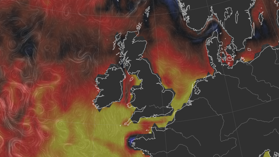
Taken together, forecasters say the combination of potential high pressure, parched soil and unusually warm seas increases the odds of another hot spell, without guaranteeing one will occur.
So will there be another heatwave, and when might we know?
The Met Office's long-range outlook for September, October and November rates the likelihood of an overall warm three-month period as "higher than normal," and warns of an "increased risk of heatwaves and heat-related impacts, especially during the first half of the period." The same outlook suggests autumn as a whole is likely to be drier than average, offering little immediate relief for a drought that the Environment Agency says will require sustained above-average rainfall over several weeks to resolve.
More recent Met Office guidance, published slightly closer to the event, strikes a more measured tone. According to a Met Office review of the weather headlines, temperatures may trend above average into early September, but a return to August's exceptional heat is not currently considered the most likely outcome. The same review points to an unsettled end to August overall, with further showers and rain and temperatures generally close to seasonal norms rather than sharply above them.
With two weeks still to go before September begins, forecasters stress that it remains too early to say precisely when, or even whether, a further heat spell will materialise; only that the underlying risk factors are in place.
They go on to say that this will bring an "increased risk of heatwaves and heat-related impacts, especially during the first half of the period."
What happens next?
The Met Office identifies early September as the key window to watch, with temperatures potentially rising briefly above average, particularly in the south, according to its latest seasonal review. The most probable scenario at this stage is a north-west to south-east split, with wetter weather more likely across north-western areas and drier conditions favoured in the south-east, though confidence in a specific late-season heatwave remains low.
Separately, the UK Health Security Agency's core heat-health alert season, which covers the period when heat warnings can formally be issued, runs from 1 June to 30 September, according to a summary of this year's heat events, meaning any late-season spike would still fall within the window for official alerts.
Key Facts
- Rain returned to much of the UK on 18 August 2026 after roughly two months, with temperatures dropping 2-4C below the mid-August average.
- 2026 is on course to be the UK's hottest summer on record, with the mid-August heatwave peaking at 38.1C.
- More than two-thirds of England and all of Wales remain in drought after the driest July on record.
- Sea temperatures around England and Wales are running up to 3C above average, which can help sustain warmth on land.
- The Met Office rates the chance of a warm September-to-November period as higher than normal, with increased heatwave risk especially in early autumn, though a repeat of August's extreme heat is not seen as the most likely outcome.


