
Autumnal leaves carpeted Liverpool's Clarkes Gardens on Tuesday as the season's colours began their annual transformation across the UK. However, the coming days will deliver a dramatic swing in conditions, with an unseasonably warm spell arriving in the south before a sharp cooling trend takes hold nationwide.
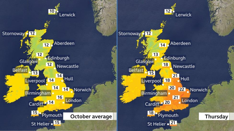
Thursday will see a stark divide in weather patterns. Warm air masses will push across southern and eastern regions, while colder conditions remain entrenched in the north and west. The boundary between these two air masses—a weather front—will bring bands of rain that gradually edge southwards throughout the day.
In parts of eastern England, afternoon temperatures are forecast to climb to around 23C (73F), which represents a departure of 5-8C (9-14F) above the typical mid-October average. According to the Met Office's latest forecast, London's high for Thursday is expected to reach 21C, making it feel distinctly out of season for late October. The contrast with the north will be pronounced: Scotland and Northern Ireland will experience temperatures hovering around seasonal norms, with highs of 12-15C (54-59F).
The warmth will be driven by brisk southerly winds generated by a deep area of low pressure positioned close to Iceland. These winds will continue to channel warm air across central, eastern and southern England, where sunny spells will develop. The Met Office has identified the remnants of Hurricane Isaias as the source of this warm spell, with the storm having impacted the southern United States on 10 October.
The rain band that has already affected Scotland and Northern Ireland will progress slowly southwards on Thursday, bringing wet conditions to northern England, Wales and parts of south-west England by afternoon. As this system clears northern areas, Scotland and Northern Ireland will transition to mostly sunny conditions with blustery winds and scattered heavy showers.
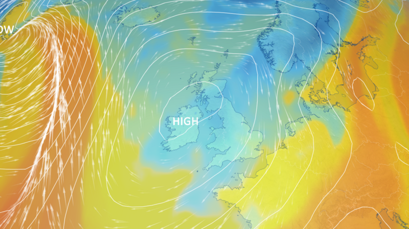
By Friday, the character of the weather will shift decisively. Colder air will spread southwards across all regions, bringing an autumnal feel that will persist into the weekend. High pressure building from the west will establish itself over the UK, delivering sunny spells across many areas and widespread northerly winds that will reinforce the chill.
Daytime temperatures across the UK will settle near the October average, ranging from 10 to 16C (50-61F). However, the wind will make conditions feel noticeably colder, particularly along the coasts of eastern Scotland and eastern England where gusts will be strongest. A few showers remain possible, especially in the north and west on Friday and in the south-east of England over the weekend.
When will frost and fog develop?
Nights will turn markedly cold as the weekend approaches. Single-digit lows are expected in almost all areas, with frost developing in many locations. Scotland, Northern Ireland and northern England are most likely to see temperatures dip below freezing, while patchy mist and fog will develop in some locations. For certain areas, particularly in the north, this could represent the coldest weather experienced so far this autumn, though it is important to note that these temperatures remain typical for mid-October. For context, the UK's October temperature record stands at 29.9C, recorded at Gravesend, Kent, on 1 October 2011.
What lies ahead beyond the weekend?
The forecast for the following week carries considerable uncertainty, with computer weather models presenting conflicting signals about the pattern. High pressure is expected to remain positioned close to the UK initially, maintaining relatively settled conditions. However, there are indications that Atlantic weather systems will eventually penetrate the high pressure, driven by the jet stream, which would bring a return to wetter, windier and somewhat milder conditions. The Met Office forecast indicates that high pressure is likely to bring a largely settled spell through the weekend and early next week, with rain most likely in the south-west before more changeable conditions develop later. The timing of this transition remains uncertain, making it advisable to monitor forecasts closely as the week progresses.
Key Facts
- Thursday will see temperatures reach 23C in parts of eastern England, 5-8C above the mid-October average
- A weather front will bring rain to northern and western areas on Thursday before clearing northwards
- Colder air will spread southwards from Friday, bringing temperatures back to seasonal norms of 10-16C across the UK
- Frost and patchy fog are likely to develop over the weekend, with some areas potentially experiencing the coldest weather of autumn so far
- High pressure will dominate the weekend and early next week, though Atlantic systems may bring wetter conditions later