For the first time in more than three decades, September passed without a single hurricane forming in the Atlantic basin—a month that typically sees the most intense tropical activity of the year. With only two months remaining in the 2026 season, forecasters are increasingly confident that the Atlantic will record zero hurricanes, an outcome that would be unprecedented in the satellite monitoring era.
Such a development would mark a historic anomaly. Since weather satellites began tracking storms in the 1960s, every Atlantic hurricane season has produced at least one hurricane. The last calendar year without any Atlantic hurricane on record was 1914, though that observation predates modern satellite technology and cannot be verified with certainty.
The primary driver of this unusual quiet is a powerful El Niño event developing across the tropical Pacific. This natural warming pattern disrupts atmospheric conditions in ways that suppress hurricane formation in the Atlantic while simultaneously fueling exceptional activity in the eastern Pacific basin.
Why does El Niño weaken Atlantic hurricanes?
El Niño alters wind patterns across the globe, with particularly significant consequences for Atlantic tropical development. As the phenomenon strengthens, upper-level winds over the Atlantic intensify, creating a condition known as wind shear—a rapid change in wind speed and direction with altitude.
This increased wind shear tears apart developing thunderstorms before they can organize into tropical systems. The vertical wind changes prevent the rotation and structure necessary for storm intensification. Simultaneously, the Atlantic's sea surface temperatures remain less favorable for storm growth compared to typical seasons.
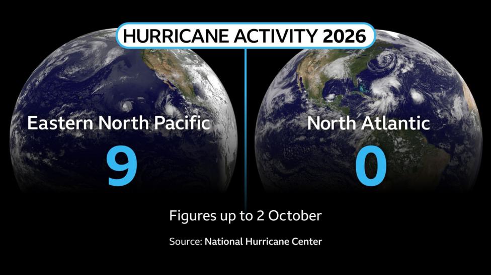
The eastern Pacific, by contrast, experiences warmer ocean temperatures and more favorable wind patterns during El Niño. These conditions provide the energy and atmospheric support that tropical systems need to develop and strengthen. So far this season, the eastern Pacific has recorded 17 named storms, including nine hurricanes—seven of which reached major hurricane status. According to NOAA's climate prediction center, there is a 75% probability that the October-to-December period will experience an El Niño stronger than any event recorded since 1950.
The accumulated cyclone energy—a measure of the total power released by storms—in the eastern Pacific is approximately two and a half times above normal at this point in the season. Temperature records in a critical region of the central-eastern Pacific have already been broken, with daily sea surface temperatures now exceeding the previous record established during the exceptionally strong El Niño of 2015.
What did forecasters predict for this season?
When the National Hurricane Center issued its May outlook, it anticipated the suppressive effects of El Niño and predicted a quieter-than-normal Atlantic season. The center forecast between eight and 14 named storms, with three to six expected to become hurricanes and one to three reaching major hurricane status.
However, more recent assessments have grown even more pessimistic about Atlantic activity. According to NOAA's September 24 outlook, forecasters assigned a 75% probability to below-normal activity, with only a 20% chance of near-normal conditions and a 5% chance of above-normal activity. That updated forecast range called for 7 to 13 named storms, 2 to 6 hurricanes, and 0 to 2 major hurricanes.
Researchers at Colorado State University, who independently monitor tropical activity, have similarly concluded that the strong El Niño will likely disrupt Atlantic wind patterns and produce below-normal activity over the coming weeks.
What tropical storms have formed so far?
Although no hurricanes have developed in the Atlantic this season, four named tropical storms did form during September: Edouard, Fay, Gonzalo, and Hanna. Of these systems, only Edouard approached land, while the others remained over open ocean waters.
Tropical Storm Fay lasted from September 19 to 29, according to NOAA's storm records, reaching maximum sustained winds of 60 knots and a minimum central pressure of 995 millibars. By early October, Fay's remnants were still producing showers southeast of Bermuda, though the National Hurricane Center assessed only a 10% chance of redevelopment within seven days due to very strong upper-level winds.
As of October 2, the Atlantic basin had recorded eight named storms but remained without any hurricanes. The total accumulated cyclone energy stood at 89% below the 1991–2020 average, underscoring the exceptional suppression of storm development this year.
How unusual is a hurricane-free season?
The possibility of a season without any hurricane would be extraordinary by modern standards. The satellite era, which began in the 1960s, has never recorded such an outcome. The historical Atlantic hurricane database extends back further, with 1914 being the last year without a recorded hurricane, but that observation predates reliable satellite monitoring and cannot be confirmed with certainty.
The typical peak of the Atlantic hurricane season occurs in early to mid-September and then gradually declines through November 30, when the season officially ends. With the season now past its historical maximum activity period and trending downward, the window for hurricane formation is narrowing significantly.
What happens next?
The National Hurricane Center indicated no signs of tropical storm activity or hurricane development over at least the following week from its latest assessment. The agency expected any remaining development chances for Fay's remnants to end by Sunday, October 4, as very strong upper-level winds continue to suppress organization.
El Niño is forecast to continue strengthening, with peak intensity expected in November or December 2026. This ongoing development should maintain the unfavorable conditions for Atlantic hurricane formation through the remainder of the season. NOAA's official outlook extends through November 30, 2026, and forecasters will continue monitoring conditions as the season approaches its conclusion.
If no hurricane forms before the season ends, it will represent a historic break from the consistent pattern observed throughout the satellite monitoring era and will underscore the profound influence that large-scale climate patterns like El Niño exert on regional weather and storm activity.