Temperatures will climb again across the UK in time for the weekend, with southern regions expected to reach 27C on Sunday. However, the period leading up to this warmth will bring wet and windy conditions to many northern areas on Friday, as low pressure systems continue to advance from the Atlantic.
Low pressure fronts rolling in from the Atlantic will primarily affect the far north of the UK, with impacts concentrated on northern and western Scotland. In contrast, high pressure building across the southern half of England and Wales will block and weaken these systems, maintaining the dry conditions that have persisted in drought-affected areas where hosepipe bans remain in place.
This pattern reflects a broader seasonal trend. Weather forecasters have highlighted a recurring pattern of warm southern spells alongside wetter, windier conditions further north, a dynamic that will continue to shape conditions through the coming days.
What will Friday bring?
Friday will feel noticeably cooler across central and southern England and south Wales, with rain expected in the morning before sunny spells develop in the afternoon. Humidity levels should also decrease, though temperatures may still reach 22C (72F).
Northern England, Northern Ireland, Scotland and north Wales will experience a breezier day with sunny spells interspersed with scattered showers, some of which could be heavy in western areas. Eastern Northern Ireland and eastern Scotland will see fewer showers and more prolonged sunshine. Gales are forecast for exposed coasts and hills in western Scotland.
How warm will the weekend get?
Saturday will be fine and dry across England and Wales as warmer air originating from France moves northward into the UK. Scotland and Northern Ireland will also see predominantly dry conditions, though a few showers are possible in the west with increasing cloud cover through the afternoon.

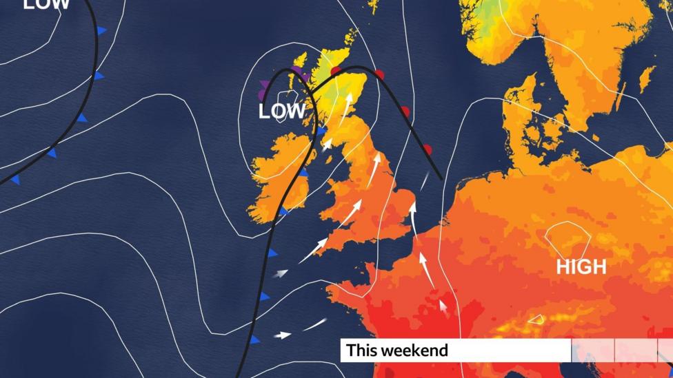
Sunday will turn cloudier and damper for much of Northern Ireland and western Scotland. South-westerly winds will draw additional warm, humid air from continental Europe, creating hot conditions where sunshine breaks through in England and Wales. Eastern Scotland is also likely to remain dry with sunny spells.
Peak temperatures on Sunday could reach 27C (81F) in south-east England, with 24C (75F) possible in Northern England, south-west England and Wales. Northern Ireland and eastern Scotland may see highs around 20C (68F).
What happens after the weekend?
Considerable uncertainty surrounds how long the warmth will persist beyond Sunday. Atlantic weather systems are expected to continue delivering westerly winds and rain at intervals throughout the following week.
Tuesday presents a particular concern, with a possibility that a deep area of low pressure could bring stormy conditions, though current distance and uncertainty make precise predictions about wind strength and rainfall distribution premature at this stage.
The Met Office's long-range guidance indicates that the first half of September is likely to remain unsettled, with showers or longer spells of rain at times and the potential for strong, gusty winds in the northwest. Monday should be bright but showery in places, with rain developing for some areas later in the day.
Looking further ahead, confidence remains low from mid-September onwards, though a gradual shift toward slightly more settled conditions is signalled for the second half of the month, with rainfall becoming less frequent and wetter spells more likely in the northwest. Temperatures are expected to remain around average overall during this period.
The next key forecast window extends from Thursday 17 September to Thursday 1 October, when a slightly more settled pattern may develop, offering a potential break from the changeable conditions dominating early September.
Key Facts
- Friday will bring wet and windy conditions to northern areas, with cooler temperatures and morning rain in the south
- Sunday temperatures could peak at 27C in south-east England as warm air from continental Europe moves northward
- Atlantic weather systems are expected to bring unsettled conditions with rain and strong winds from mid-week onwards
- The first half of September is forecast to remain changeable with showers and potential for strong winds in the northwest
- More settled conditions may develop from mid-to-late September, though confidence in predictions remains limited