The United Nations General Assembly has voted to endorse a new world map projection that more accurately represents the size of Africa, moving away from the centuries-old Mercator projection that has distorted the continent's dimensions on globes and atlases worldwide.
On September 4, 2026, the "Correct the Map" resolution, sponsored by Togo and supported by African Union member states, secured backing from 164 nations, including France and the UK. According to , the United States cast the sole vote against the measure, with six nations abstaining. The resolution is non-binding but is expected to influence how institutions and technology companies around the world display geographical information.
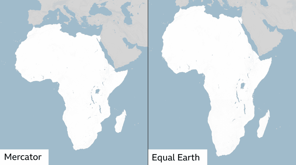
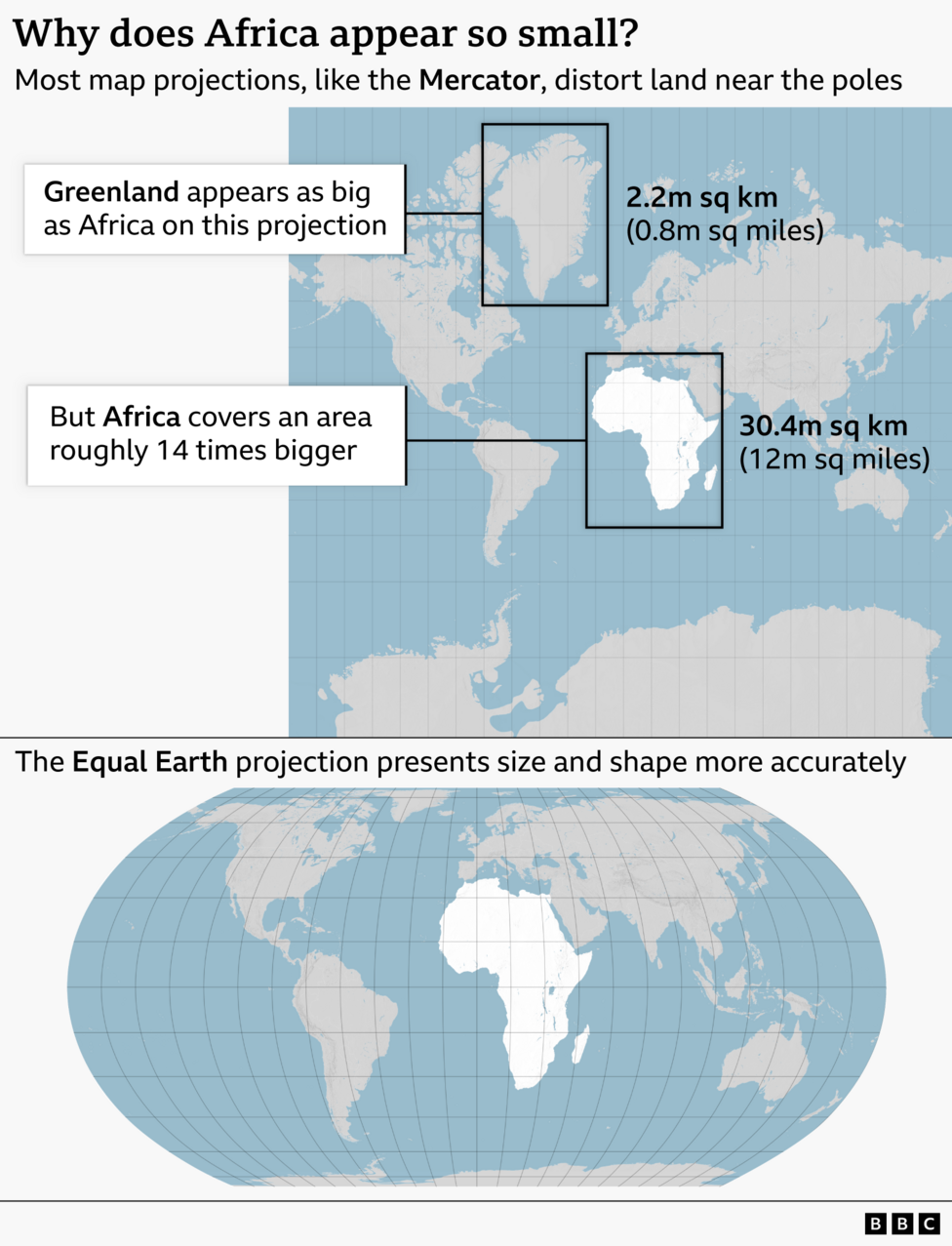
The Mercator projection, in use since its creation in 1569 by Flemish cartographer Gerardus Mercator, has long faced criticism for its severe distortions of land area, particularly affecting regions near the equator. The projection depicts Africa as roughly equivalent in size to Greenland, despite Africa covering approximately 30.4 million square kilometres compared to Greenland's 2.2 million—making Africa roughly 14 times larger.
Cartographers and development advocates have argued that these visual misrepresentations shape global perceptions of continents and nations, potentially minimising the perceived importance and development potential of equatorial regions.
A map is never neutral. It shapes perceptions, influences how the place of peoples and continents in the world is understood.Togolese Foreign Minister Robert Dussey made this argument at a UN briefing ahead of the vote, emphasising that
a fair world begins with a fair map.
Why does the Mercator projection distort land sizes?
The Mercator map's distortions stem from a fundamental challenge in cartography: it is mathematically impossible to accurately represent the curved surface of a globe on a flat, two-dimensional surface without making compromises. The Mercator projection was originally designed in 1569 to assist European explorers with maritime navigation by preserving directional accuracy. However, this navigational advantage comes at the cost of severely misrepresenting land areas. The projection makes countries near the equator appear smaller than they actually are, while countries closer to the poles appear disproportionately large.

What is the Equal Earth projection?
In response to these longstanding concerns, a team of cartographers developed the Equal Earth projection in 2018, an equal-area map designed to represent all continents with greater accuracy. According to , the African Union's 54 member states formally adopted the Equal Earth projection in February 2026, stating it
more accurately represents the sizes of all continents, particularly Africa.The resolution endorsed by the UN General Assembly supports the adoption of this projection as an alternative to the Mercator map.

What was the US position on the vote?
The United States opposed the resolution, marking it as the sole nation to vote against the measure. According to , the US stated it opposed the resolution because it promoted an "ideological agenda" and distracted from "genuine problems of international peace, prosperity or good relations." However, Togo's ministry clarified that the resolution does not challenge the Mercator projection's continued use for maritime and aerial navigation, where its directional properties remain valuable.
How does this connect to recent map controversies?
The UN vote comes months after a significant embarrassment involving US government cartography. In July 2026, a US government map displayed at the Aids 2026 conference in Rio de Janeiro mislabeled every African country, prompting criticism and a State Department apology. That incident underscored broader concerns about how Africa is represented in official and public materials globally.
What happens next?
The campaign for map reform will continue beyond the UN vote. According to , Togo has planned a follow-up implementation event in Lomé scheduled for the first quarter of 2027, bringing together UNESCO, the African Union, and major technology companies including Google Maps to discuss how the Equal Earth projection can be integrated into widely used mapping platforms and educational materials. The UN's geospatial body, UN-GGIM, is also reviewing the request through its committee of experts to support the transition.
Key Facts:
- The UN General Assembly voted 164-1 on September 4, 2026, to endorse the Equal Earth projection as an alternative to the Mercator map.
- Africa is approximately 14 times larger than Greenland, yet appears similar in size on Mercator projections.
- The Equal Earth projection was created in 2018 and adopted by the African Union in February 2026.
- The resolution is non-binding but is expected to influence how institutions worldwide display maps.
- Implementation discussions involving Google Maps and UNESCO are scheduled for early 2027.