As November approaches, the UK has yet to experience its first named storm of the season, a situation that reflects the unusual weather patterns dominating autumn so far. According to BBC News, deep Atlantic low-pressure systems that typically bring turbulent conditions have been deflected away by persistent areas of high pressure. Instead of gales and disruption, the headlines have centred on worsening drought across parts of the country.
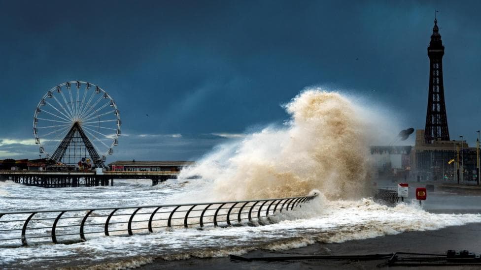
However, meteorologists suggest this calm period may not last. The Met Office predicts a growing likelihood that late autumn and early winter will turn significantly wetter and windier as El Niño strengthens in the Pacific, potentially ending the current dry spell and ushering in a more active storm season.
Why has autumn been so quiet so far?
As the season progresses and nights lengthen, temperatures around polar regions begin to drop. This temperature contrast with the warmer tropics normally energises a more powerful jet stream—the fast-moving, narrow band of winds high in the atmosphere that plays a crucial role in weather systems.
The jet stream is the primary driver behind the development and delivery of stormy pressure systems to the UK. Typically in autumn, it would be a regular presence above British skies, steering wet and windy weather our way. This year, however, the jet stream has frequently positioned itself to the north or north-west of the UK, allowing south or south-westerly winds to bring warmer-than-normal conditions and giving high pressure greater influence over the weather pattern.
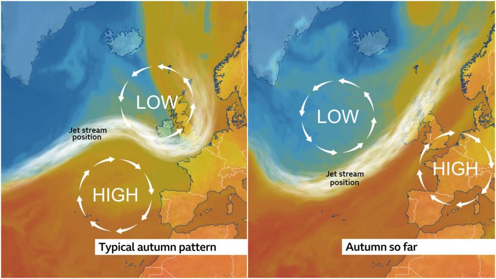
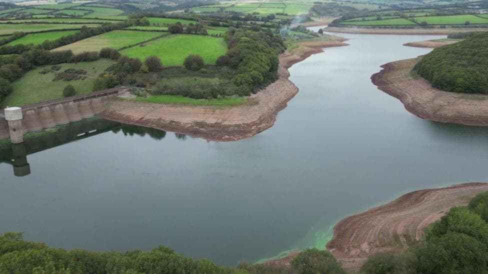
This positioning has resulted in only occasional bursts of stronger winds across the north-west, with minimal disruption to most areas. Rainfall has been concentrated across Scotland and Northern Ireland, while large parts of England and Wales have remained much drier than their seasonal average. In Herefordshire, for example, only a tenth of the expected rainfall had fallen by mid-October. The southern regions have been particularly affected, with exceptionally low reservoir levels prompting the Environment Agency to declare "severe drought" in some areas. According to government data, England's October rainfall through 8 October ranged from 6% of the long-term average in the east and south-east to 16% in the north-west and north-east.
Could wetter and windier weather be approaching?
A shift in the jet stream's position and strength is anticipated over the coming weeks. This change will allow deeper low-pressure systems to affect more parts of the UK, marking a transition to more widespread wet and windy conditions. Forecasters emphasise that predictions must be monitored closely, as there is potential later in the week for the first spell of widely disruptive weather this season to develop.
Longer-term signals point to increased rainfall and storminess later in autumn and early winter. The Met Office's three-month outlook for October, November and December forecasts double the normal chance of wetter weather and 1.3 times the normal chance of windier weather—patterns consistent with those observed during previous El Niño events. In preparation for this shift, the UK launched a flood taskforce ahead of a winter outlook with an increased likelihood of wetter-than-average conditions.
Recent developments have already hinted at the changing pattern. A yellow wind warning was issued for parts of the Highlands and Western Isles, where gusts could reach 70 mph, as remnants of Hurricane Isaias brought gales and heavy rain on 13–16 October. The Met Office's week-ahead outlook anticipated some rain and showers initially, followed by a growing chance of drier conditions as the weekend progressed, suggesting a transitional period ahead.
When are storms typically named and what triggers the process?
Storms receive names when potentially damaging winds are forecast, though they can also be designated for flooding rain or disruptive snow. The naming system was introduced to raise public awareness of severe weather episodes, enabling people to prepare and minimise the worst impacts through advance planning.
In Europe, five storm-naming groups operate, each created by meteorological agencies from similar geographic regions. The UK, Ireland and the Netherlands form the western group, which began naming storms in 2015. The UK's Met Office, Ireland's Met Éireann and the Netherlands' KNMI collaborate to name weather systems based on expected impacts and their likelihood. The Met Office's 2026–27 storm-name list begins with Austen, Boelo and Chloe; a storm is named when it could cause disruption or damage warranting an amber or red warning.
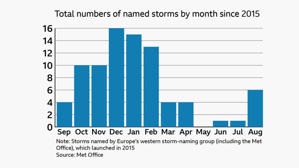
Although named storms can occur at any time of year, analysis reveals they are far less common in spring and early summer. May is the only month in the eleven years since the UK began naming storms that has experienced no named storms at all. The frequency of named storms increases from late summer through autumn, with the peak arriving during the winter months of December, January and February. This seasonal pattern is why the storm-naming season begins in September each year.
It is not unusual to still be waiting for the first named storm at this stage of the year. Historical data shows that in approximately half of the years since 2015, the first storm did not arrive until after 1 November. The previous winter brought four named storms—Bram, Goretti, Ingrid and Chandra—and England received 42% more rainfall than its winter average, demonstrating the potential for significant weather activity once the season truly begins.