

Successive heatwaves across western Europe since May 2026 have left visible scars on the landscape, according to satellite imagery reviewed for this analysis. The images show shrinking Alpine glaciers, wildfire-scorched terrain, fields turned brown instead of green, and rivers running at unusually low levels. The European Union's climate monitoring service, Copernicus, has confirmed that western Europe recorded its hottest June-to-July period since records began.
Some well-known sites have not been spared either. In the satellite images, the Palace of Versailles, just south of Paris, now stands out as a patch of green trees surrounded by parched, brown farmland.

Why has it been so hot?
According to the Met Office, the immediate trigger for the heatwaves has been a series of stubborn high-pressure systems that brought clear skies and allowed temperatures to climb steadily. Longer term, decades of rising average temperatures driven largely by the burning of fossil fuels have made intense, prolonged hot spells increasingly likely, a pattern scientists link directly to human-caused climate change.
How low have Europe's rivers fallen?
Water levels on the Danube, Europe's second-longest river, have sunk to their lowest point in three decades across several countries. The falling waters have exposed long-hidden objects on the riverbed, including mammoth bones uncovered in Bulgaria and a sunken Second World War-era warship that resurfaced in Serbia.
Along stretches of the Danube running through Hungary and Romania, nuclear power stations have had to reduce output or shut down entirely because there was not enough river water available for cooling systems. On the Rhine, cargo ships have been left stranded and river cruise operators have cancelled sailings.
The situation has worsened since these initial disruptions. According to the European Commission's Joint Research Centre, four of the continent's major rivers — the Loire, Po, Rhine and Danube — hit record-low levels in August 2026 as drought conditions intensified through July and August. Separately, industry monitoring reported by ICIS found that the Rhine at Kaub fell to just 19cm on 5 August 2026, with further declines forecast, a drop that has already triggered force majeure declarations in chemical logistics alongside the nuclear shutdowns.
What is happening to Alpine glaciers?
Even the high, snow-covered peaks of the Alps have felt the effects of the heat. Ongoing monitoring suggests this summer could rank among the worst on record for glacier melt in the region, and more than a month of the melt season still remained at the time of writing.
A mild winter left glaciers with thinner-than-usual snow cover by the end of April 2026, and an unusually early heatwave in May accelerated the loss of that snow. This exposed bare ice beneath, leaving glaciers more vulnerable to rapid melting during the heatwaves that followed.
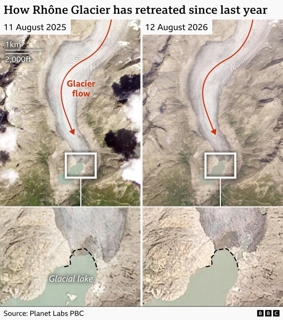
Satellite imagery indicates that the front edge of the Rhône Glacier in Switzerland has retreated by 50 metres (160 feet) or more compared with the same point last year. In a stable climate, glaciers would typically stay roughly the same size over long periods rather than shrinking year on year.
Dr Lander van Tricht, a glaciologist at the Swiss Federal Institute of Technology, said recent years have brought a marked shift in Alpine conditions.
"much less snow in winter and much, much more melt in summer."
He added a warning about the trajectory the region is on.

"And if we continue this trend, then the future looks very dramatic for the Alps."
How badly have wildfires scorched the land?
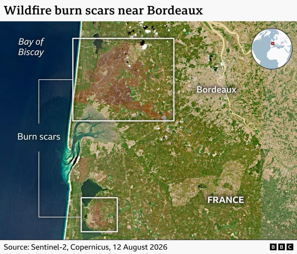
Wildfires have reshaped parts of western Europe's landscape this summer. More than 90,000 hectares (900 sq km, or roughly 350 sq miles) have burned in France, making 2026 the country's worst year on record according to the European Forest Fire Information System.
The largest single fire struck the Gironde region, home to the city of Bordeaux, burning around 42,000 hectares — an area comparable in size to the Isle of Wight.
Dr Douglas Kelley of the UK Centre for Ecology and Hydrology said tinder-dry land has been a major factor behind this year's severe fire activity, noting that extreme wildfires are becoming
"more and more frequent"
as climate change produces ideal fire conditions, with higher temperatures drying out vegetation and soil more quickly.
Wide-angle satellite images of western France show a marked increase in land turning brown compared with the previous year. To measure whether this summer is genuinely unusual, analysts used the Normalised Difference Vegetation Index (NDVI), a satellite-derived measure of vegetation health in which lower readings signal sparser or more stressed plant growth.
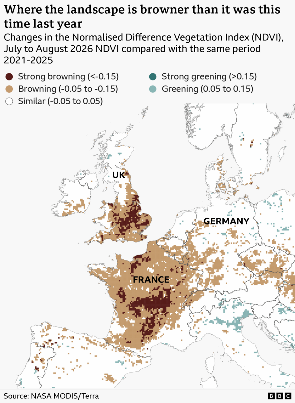
This summer's NDVI readings fell below a five-year benchmark covering 2021 to 2025 across roughly 70% of France, close to half of the UK, and about 40% of western Germany. Prof Andrew Challinor of the University of Leeds said the pattern in the images is
"consistent with widespread water stress"
which he said
"does not bode well"
given how much of Europe's farmland could be affected, with knock-on risks for the agriculture sector and food production.
Prof Luis Samaniego of the Helmholtz Centre for Environmental Research said soil moisture in the worst-hit areas is lower than roughly 98% of comparable dates in the historical record. He cautioned that even if rain eventually returns, some of the damage already done to crops and land may be irreversible.
How does this summer compare with past records?
Copernicus has confirmed that July 2026 was the second-warmest July on record for western Europe, with an average surface air temperature of 22.48°C, according to the European Space Agency's Copernicus programme. Across European land more broadly, July 2026 ranked as the eleventh-highest July on record, with an average temperature of 20.49°C — 0.66°C above the 1991-2020 average, according to Copernicus's climate service.
Taken together, the combined June-July period in western Europe averaged 21.62°C, some 2.79°C above the long-term average and higher than the previous record set in 2022, according to figures reported by Al Jazeera. Copernicus has also reported that river flows across much of the affected region have fallen to much-below-average or extremely low levels, disrupting sectors ranging from energy generation to shipping, according to its climate bulletin. Western Europe experienced its third and fourth heatwaves since May by the time of the July data, accompanied by extreme wildfires and exceptionally low rainfall and soil moisture in parts of France, Spain, Germany and the UK, Copernicus noted.
What happens next?
Forecasters expect little immediate respite. According to Euronews, a further heatwave was building across much of the continent, with temperatures forecast to exceed 35°C in areas affecting more than 135 million people. Reporting from France 24 indicated Europe was bracing for this additional blast of extreme heat even as drought, wildfires and record-low river levels continued to worsen. The new wave of heat was expected to persist across large parts of the continent beyond 13 August 2026, with tens of millions of people facing temperatures in the mid-30s Celsius or higher.
Key Facts
- Western Europe recorded its hottest June-to-July period on record, averaging 21.62°C, 2.79°C above the long-term average.
- More than 90,000 hectares have burned in France this year, its worst wildfire season on record, including a 42,000-hectare blaze in Gironde.
- The Rhône Glacier's front has retreated by 50 metres or more year-on-year, with the Rhine at Kaub falling to a record 19cm on 5 August 2026.
- Four major European rivers — the Loire, Po, Rhine and Danube — reached record-low levels in August 2026.
- A further heatwave was forecast to bring temperatures above 35°C to more than 135 million people after 13 August 2026.


