A powerful El Niño event developing across the Pacific Ocean is forecast to become the strongest in living memory, with the potential to surpass any recorded since the 19th century, according to warnings from the Met Office and international climate agencies.
The natural climate phenomenon, which occurs roughly every two to seven years, is already pushing global temperatures higher and disrupting weather patterns worldwide. When combined with human-induced climate change, forecasters warn it is "very likely" that 2027 will become the hottest year on record, displacing 2024 from that position.
Prof Adam Scaife, head of long-range forecasting at the UK Met Office, emphasized the exceptional nature of the current event:
"We should be clear that this is an unprecedented event. I have never seen an El Niño signal this intense in our forecasts."
Evidence of the phenomenon's effects is already visible across multiple regions. India is experiencing below-average monsoon rainfall, while hurricane activity in the Atlantic Ocean remains suppressed. According to NOAA's latest ENSO discussion, there is a greater than 90% chance of a very strong El Niño during fall and winter 2026-27.
How does El Niño develop and intensify?
El Niño begins when trade winds that typically blow from east to west across the Pacific Ocean weaken or reverse direction, allowing warm water to spread eastward. Heat released from the ocean into the atmosphere raises global temperatures and shifts rainfall patterns across the planet.
Scientists formally declare an El Niño when sea surface temperatures in a key Pacific region reach 0.5°C or more above average. Current measurements show temperatures well over 2°C above normal, with forecasts suggesting anomalies could exceed 3°C as the event approaches its peak later this year—a level unprecedented in records dating back to 1950.
Exceptionally high temperatures in deeper ocean layers are amplifying this event. Water temperatures around 8°C above normal at depths of approximately 100 metres in some locations are acting as a reservoir of warm water that reinforces and sustains the phenomenon. The Met Office has noted that forecasts suggest sea-surface temperature anomalies in the central and eastern tropical Pacific could exceed 2°C, with some international climate groups projecting even higher values.
Dr Zeke Hausfather, a climate scientist at Berkeley Earth, a US research group, explained the significance of these measurements:
"We have many months to go while this event continues to develop and that's one of the reasons that we have increased confidence that this will be a record-setting event."Some climate organizations have projected temperature anomalies potentially reaching 4°C above average. Should this occur, Hausfather noted that
"It's not beyond the realm of possibility to say this might be the strongest El Niño event in 500 or even 1,000 years,"though he acknowledged the impossibility of confirming such claims for periods before instrumental records began.
What regional weather impacts are already occurring?
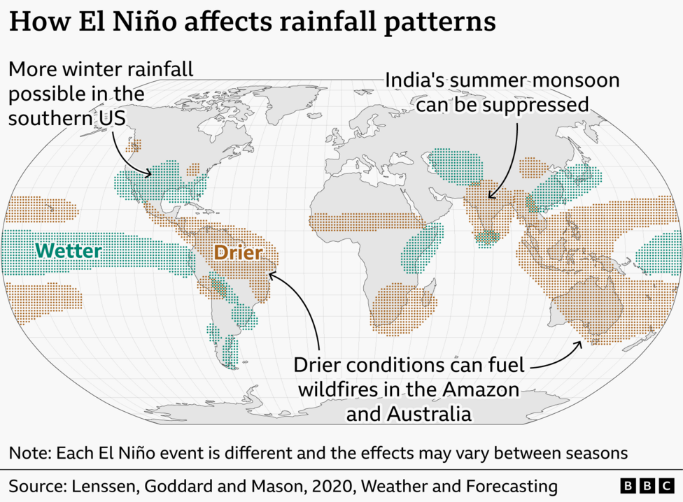
El Niño's effects on global weather are not uniform, as each event produces different regional consequences. However, current evidence demonstrates that impacts are already materializing across multiple continents.

In South Asia, the southwest monsoon is delivering significantly suppressed rainfall during 2026, running well below historical norms. The Caribbean and tropical Atlantic have experienced reduced hurricane activity, with only three named storms occurring so far this season—a marked decrease from typical patterns.
Regions near the tropical Pacific face particularly severe consequences. Australia faces elevated risks of drought and bushfires, while Peru, Ecuador, and the southern United States confront increased flooding threats. The World Meteorological Organization warned that a strong El Niño was developing and expected to intensify during August–October 2026, with potential to worsen these regional impacts.
How will El Niño affect UK weather patterns?
The record-breaking heatwaves that dominated the UK's summer of 2026 were not primarily driven by El Niño, though the phenomenon is expected to exert greater influence during the autumn and early winter months ahead.
Forecasters anticipate increased potential for wet and stormy conditions across north-west Europe, including the United Kingdom, as El Niño's effects intensify. Counterintuitively, the phenomenon can also increase the likelihood of cold weather episodes late in winter, though these connections remain relatively weak and less predictable than other regional impacts.
Why is 2027 forecast to be the hottest year on record?
During El Niño events, substantial quantities of heat transfer from the ocean into the atmosphere. This process typically produces the most pronounced warming effects during the calendar year following the winter peak of the El Niño cycle.
Dr Nick Dunstone, a climate scientist at the Met Office, explained the mechanism:
"an increase in global average temperature, particularly in the calendar year following the winter peak of the El Niño. Hence, 2027 is very likely to replace 2024 as the warmest year on record."
The combination of this natural climate phenomenon with ongoing human-induced warming creates conditions for exceptional global temperature increases. NOAA said the October–December 2026 season carries a 69% chance of a historic event exceeding previous El Niño events dating back to 1950, reinforcing forecasts of record-breaking warmth in 2027.
What are the broader humanitarian and economic implications?
Beyond weather and temperature impacts, this El Niño event carries significant consequences for global food security and economic stability. Earlier this month, the UN's Food and Agriculture Organization warned that El Niño could threaten tens of millions of people in vulnerable countries with crisis-level acute food insecurity, compounding existing challenges from climate change and conflict.
What happens next?
El Niño is expected to continue strengthening through the end of 2026 and persist through Northern Hemisphere spring 2027, according to forecasts from the US National Oceanic and Atmospheric Administration. The International Research Institute for Climate and Society indicates little sign of transition away from El Niño conditions before spring 2027, meaning the exceptional warming and weather disruption documented in this article will likely intensify further before beginning to subside.
Key Facts:
- Sea surface temperatures in the central Pacific are currently over 2°C above normal, with forecasts suggesting they could exceed 3°C—unprecedented in records since 1950
- A greater than 90% probability exists for a very strong El Niño during fall and winter 2026-27, with some forecasts suggesting this could be the strongest event in 500 to 1,000 years
- 2027 is "very likely" to become the hottest year on record, surpassing 2024, due to heat released from the ocean during the El Niño peak
- Current impacts include suppressed monsoon rainfall in India, reduced Atlantic hurricane activity, and elevated drought and flooding risks in tropical Pacific regions
- The UN Food and Agriculture Organization warns El Niño could threaten tens of millions of people with acute food insecurity in vulnerable nations