

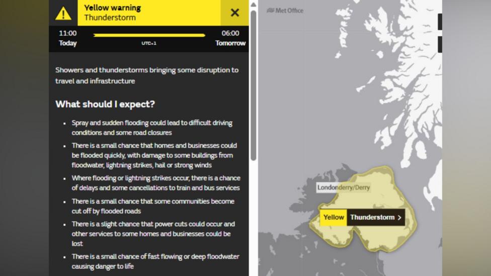
Northern Ireland is under a Met Office thunderstorm warning while forecasters wait to see whether a fourth heatwave of the summer will be confirmed later on Thursday. The warning took effect at 11:00 BST and remains in force until 06:00 on Friday, with severe storms capable of bringing sudden downpours, lightning, hail and gusty winds.
If a location such as Armagh registers a temperature of 25C later on Thursday, it would meet the Met Office's criteria for a heatwave — three consecutive days at or above that threshold — making it the fourth such spell of the year and the highest number since the Met Office began formally tracking heatwaves in 2019.
The wider heat is being felt across the island of Ireland, with the Republic recording higher temperatures still. Met Éireann has issued a yellow-level heat alert covering Leinster and Tipperary, which stays in force until 06:00 local time on Friday 14 August.
Why is there disagreement over what counts as a heatwave?
Not every forecaster uses the same yardstick. While the Met Office defines a heatwave as three or more consecutive days above 25C, Met Éireann's June 2026 climate statement sets a stricter bar, requiring five consecutive days above the same threshold before declaring a heatwave. That difference helps explain why the two forecasters can describe the same warm spell in different terms even when temperatures are similar on both sides of the border.
How severe could the storms get?
Forecasters have warned that where thunderstorms do break out, they could be intense and long-lasting.
Where the storms do develop this afternoon, they will rumble on through the evening and overnight, occasionally merging into longer spells of rain
The Met Office said the atmosphere is currently unstable, warm and humid, conditions that can trigger locally severe thunderstorms. Many areas will avoid the worst of it, but where storms do form, the Met Office said "10-20 mm of rain could fall in less than an hour, with a chance of a few areas seeing 20-30 mm in less than an hour," adding that this could lead to some localised flooding.

How does this compare with earlier heat this summer?
Northern Ireland has already had an unusually active summer for high temperatures. An officially confirmed heatwave in mid-July saw temperatures exceed 25C for three consecutive days, while similarly hot conditions were recorded in the Republic of Ireland at the same time, prompting water restrictions there.
Even earlier in the season, Northern Ireland came close to its all-time temperature record before the Met Office confirmed 30.8C at Castlederg on 25 June 2026, according to a Met Office review of June's temperature records, which matched the region's long-standing June record set in 1976. Meanwhile, the Republic of Ireland has been on course for its longest heatwave since 1976, according to a national broadcaster's report, underlining how exceptional the wider warm spell across the island has been this year.
Elsewhere in the UK, a fourth heatwave of the year is also under way, though forecasters say Scotland and Northern Ireland are likely to stay comparatively cooler and showery, with highs generally ranging from the high teens to the low-to-mid 20s Celsius, according to BBC Weather.
What happens next?
Once the current storms clear, fresher and less humid air is expected to move in from the Atlantic on Friday, bringing lower temperatures both by day and overnight. Despite that shift, the Met Office's wider UK heatwave update suggested Northern Ireland could still reach around 27C on Friday and roughly 25C on Saturday, according to the Met Office, before conditions ease further.
In the Republic of Ireland, Met Éireann's yellow heat alert for Leinster and Tipperary is due to remain active until 06:00 local time on Friday 14 August, after which conditions there are also expected to moderate.
Key Facts
- A Met Office thunderstorm warning for Northern Ireland runs from 11:00 BST Thursday to 06:00 Friday.
- A 25C reading in Armagh later on Thursday would confirm a fourth heatwave this summer — the most since records began in 2019.
- Storms could bring 10-20 mm of rain per hour, with isolated totals of 20-30 mm and a risk of flooding.
- Met Éireann's yellow heat alert for Leinster and Tipperary lasts until 06:00 on Friday 14 August 2026.
- Cooler Atlantic air is due to arrive on Friday, though highs of around 27C and 25C are still possible on Friday and Saturday respectively.


