
The Met Office has issued yellow weather warnings for a significant outbreak of heavy rain and thunderstorms expected to sweep across large parts of the UK from Wednesday through Thursday. The alerts cover east Wales, the Midlands, northern England, East Anglia and southern England, including London, marking one of the most widespread heavy rain events across southern and central regions this summer.
While the rainfall will bring relief to areas affected by prolonged dry conditions, the combination of hard, parched ground and intense downpours poses a serious flash flooding risk. In addition to flooding, the storms may produce lightning, large hail and gusty winds across the affected zones.
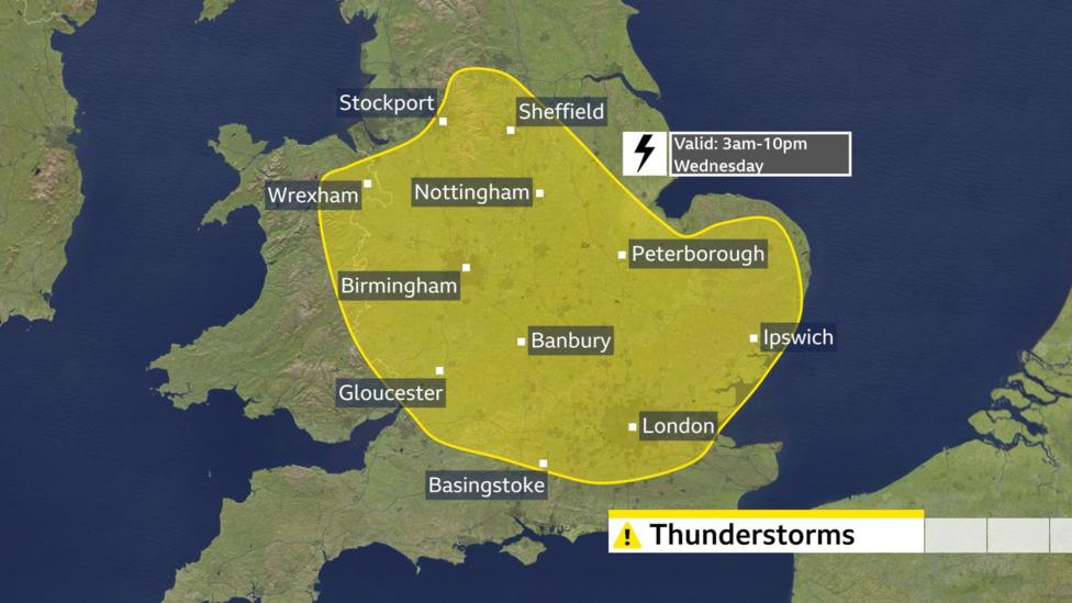
According to the Met Office's forecast update, heavy showers, thunderstorms and locally significant rainfall are expected from the middle of the week, with a more organised area of thundery rain approaching southwestern areas later in the day. The unsettled spell follows a period of dry conditions in parts of the UK, which meteorologists have identified as a factor that can increase surface-water flooding risk when rain arrives suddenly.
When will the storms arrive?
The first band of thunderstorms will develop as warm and humid air moves northwards from France, initially bringing a few showers to Cornwall and the West Country during Tuesday evening. Heavier downpours with thunder and lightning are forecast to arrive later that night, with the first band of heavy showers reaching the southeast coast of England around midnight before crossing Greater London and moving northwards into the home counties and East Anglia.
The first yellow weather warning comes into force at 03:00 BST on Wednesday and remains in effect until 22:00 BST. While not all locations within the warning area will experience thunderstorms, those that do face flooding risk, with 20-30mm of rain possible in less than an hour. The hardest hit locations could accumulate 40-50mm within two to three hours. During Wednesday morning, the storms may spread further north into the Midlands and the Peak District, though the forecast becomes less certain regarding location and intensity.

What rainfall totals are expected?
The storms and downpours are forecast to continue into Thursday, with some potentially becoming slow-moving across the Midlands, Wales and Northern England, leading to additional flash flooding. Many areas could experience 20-30mm of rain in just three hours, with up to 50mm possible in some locations. The Met Office has indicated there is also a small chance of considerably higher totals, particularly over east-facing higher ground, where more than 75mm could fall within 12 hours.
Lightning may be frequent during the heaviest downpours, and hail of around 1-2cm could fall in the most intense cells. The weather pattern is linked to low pressure moving in from the southwest, bringing an unsettled period with heavy downpours and thunderstorms likely each day through the period.
Why are thunderstorms so difficult to forecast?
Thunderstorms present a significant forecasting challenge because they can develop very quickly and operate on a relatively small spatial scale. Tiny variations in temperature, humidity, wind and atmospheric instability can determine whether a storm forms at all or the precise direction it will travel. Forecast models can often identify the risk of thunderstorms across a wider area, but pinpointing exactly where and when an individual storm will strike remains extremely difficult. Even a difference of a few kilometres can mean the distinction between a torrential downpour with thunder and lightning and an area that remains completely dry.
What happens next?
The Met Office's next published update indicates that heavy rain and thunderstorms are expected to continue through Thursday and move slowly northwards through England and Wales. Live weather forecasts suggest the warning remains current through the period, with further updates likely as the situation develops. Residents in affected areas should monitor official weather alerts closely and prepare for potential disruption from flooding and severe weather.
The arrival of this significant rainfall system will mark a notable shift from the recent dry spell that has affected parts of the country, though the intensity and speed of the downpours mean that the ground's reduced ability to absorb water quickly will remain a critical concern for flood risk management.