A collapsed glacier has been identified as the cause of a catastrophic flash flood that struck the Nepal-Tibet border, killing at least 177 people and leaving hundreds missing, according to preliminary scientific investigations. Initial confusion about the disaster's origin arose when early reports suggested an earthquake had triggered a landslide, but the US Geological Survey later clarified that a "glacial collapse"—the disintegration of a glacier or part of a glacier—was responsible.
The impact of the glacier breaking apart and descending into a valley proved so violent that it registered a magnitude of 5.2 on seismic instruments, according to USGS data and scientists who have studied the event. According to , Nepal's prime minister's office reported that 95 bodies had been recovered and 484 tourists were missing, while China reported three deaths and 265 missing in Gyirong on its side of the border.
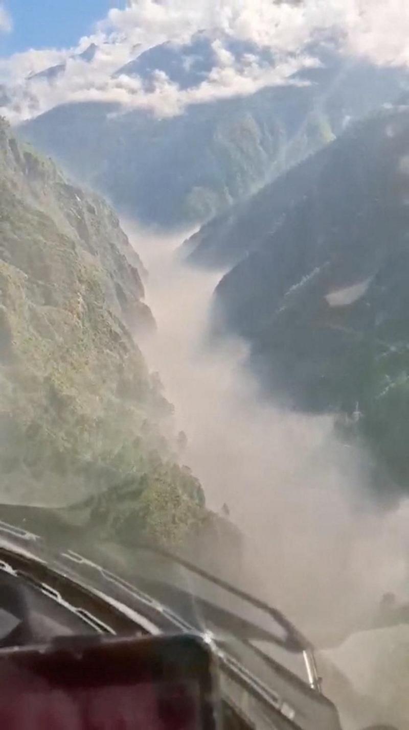
The surge struck the Bhote Koshi River around 9:00 a.m. before moving downstream into the Trishuli River toward Nuwakot. According to CNN, Nepal deployed helicopters for rescue operations after the flood damaged roads, bridges and energy facilities near the Tibetan border.
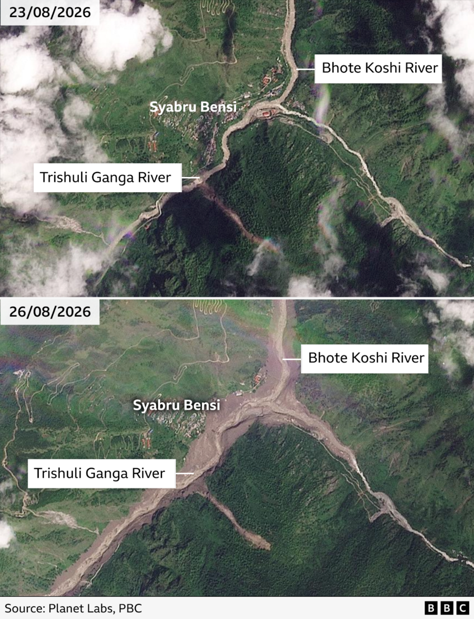
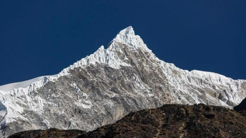
Dr Simon Cook, a glacier expert with the University of Dundee, identified the specific location of the collapse. His team detected that the lower section of a glacier in Nepal near the Langtang Lirung peak—approximately 15 kilometres (9 miles) west of where the floods occurred—had disintegrated. Cook estimated that the glacier collapsed in a northwesterly direction and then travelled westwards downstream.
An analysis by the International Centre for Integrated Mountain Development (ICIMOD), an intergovernmental scientific institution, found evidence of "an ice-rock avalanche originating from a high-altitude area". This event sent "a large volume of ice and rock debris" into the Lende Khola, a tributary of the Bhote Koshi river, which generated a sudden and violent surge in river flow carrying water, sediment and large boulders downstream. The centre's findings showed that water levels in rivers downstream rose between seven to nine metres within just 30 minutes, and several water monitoring stations were washed away or damaged.
How did the glacier collapse trigger such a devastating flood?
Mike Searle, a professor of earth sciences at Oxford University, explained that the entire sequence—from initial collapse to catastrophic flooding—could have unfolded over hours or even days.
The sheer wave of debris suggests there could have been a landslide first; the water built up, dammed the river, and then it burst in one huge great flood.The topography of the region intensified the disaster's severity. Searle noted that Langtang Lirung sits on the crest of the high Himalayas with "incredibly steep valleys" on both sides of the mountain, which funnelled the water at higher speeds and concentrated its destructive force.
What caused the glacier to collapse?
Scientists remain uncertain about the precise trigger for the glacier's failure on 26 August 2026. Searle explained that Langtang Lirung, like the rest of the Himalayas, has been slowly rising due to long-term tectonic movement, where one plate has been pushing another plate upward.
It's like putting a jack under the car, and then jacking it up.As the mountain rises, the glacier becomes progressively steeper, making it inevitable that sections break away. Typically, these are smaller fragments that temporarily obstruct rivers and are easily flushed out. However, in this disaster, the entire glacier appears to have collapsed "in one go", which Searle described as "very unusual".
These floods happen all the time, but not at this scale.

Searle attributed the exceptional magnitude of the event to the convergence of two distinct processes.
The whole thing is combining to form these catastrophic disasters that we are now seeing at a regular basis.One factor is tectonics—the continuous uplift of the Himalayas—and the other is climate change, which has brought increasingly high temperatures and accelerated glacier melting.
How does climate change contribute to these disasters?
Scientists have warned for years about the consequences of melting ice and permafrost—centuries-old frozen soil—in the Himalayas due to climate change. An analysis released by ICIMOD earlier in 2026 found that Hindu Kush Himalaya glaciers are now losing ice at double the rate since 2000, a trend that exacerbates flooding hazards. Dr Cook noted that similar incidents of floods and landslides triggered by glacier collapses have occurred recently in India, Switzerland and Italy.
In 2021, a large section of a Himalayan glacier collapsed in the Chamoli valley in northern India, sending a cascade of debris and water downstream that killed 200 people. Scientists later estimated that the impact of that collapse was equivalent to 15 atomic bombs. Even in Nepal, the same region experienced flooding the previous year caused by a glacial lake in Tibet bursting.
Mohd Farooq Azam, a specialist with ICIMOD, observed that the increasing frequency of hazards in the cryosphere—the frozen parts of the Earth—"is becoming more visible than ever before. The pace of change is so rapid." While it is difficult to attribute any single event definitively to climate change, the pattern of such disasters suggests a clear connection. Dr Cook explained:
The logic is that with a warming planet, you will see shrinking glaciers, lots of snow melt. The permafrost that is partially holding some mountainsides together is warming and thawing and degrading.
So you are going to get more landslides, debris flows, glacial meltwater, lake outbursts, glacier collapses, because climate warming ultimately destabilises these high mountain environments.
What is the current scale of the disaster?
According to , of the 484 missing tourists reported by Nepal's authorities, 391 were foreigners and 93 were Nepalis. The disaster has affected nationals from multiple countries, with significant numbers of British, American and Canadian citizens among those unaccounted for. The flood destroyed villages, infrastructure and critical trading routes to China, causing widespread damage across the region.
What happens next?
Authorities have extended high-risk warnings downstream to Nuwakot, Dhading, Gorkha and Chitwan as the flood moves into the Trishuli basin. Nepalese authorities are continuing rescue and recovery operations, with death tolls and missing-person counts still being updated. Flood warnings remain in place for downstream districts as river levels are projected to rise further.
Key Facts:
- A collapsed glacier near Langtang Lirung peak triggered the flash flood, with the impact registering magnitude 5.2 on seismic instruments
- Water levels in downstream rivers rose between 7–9 metres within 30 minutes, destroying monitoring stations and infrastructure
- The disaster resulted from the combination of tectonic uplift and climate-driven glacier melting, a pattern becoming increasingly common in the Himalayas
- Hindu Kush Himalaya glaciers are losing ice at double the rate since 2000, according to ICIMOD analysis
- Similar glacier-collapse disasters have occurred in India, Switzerland and Italy in recent years, with the 2021 Chamoli collapse in India killing 200 people