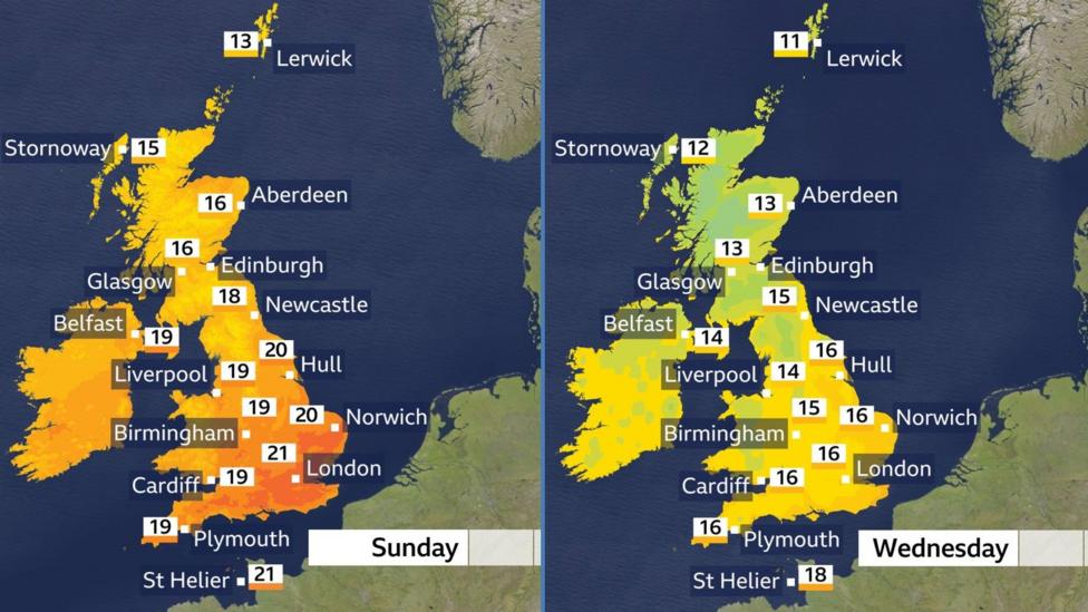
A sharp temperature drop is set to sweep across the United Kingdom during the coming week, ending a prolonged spell of unseasonably warm autumn conditions. By Wednesday, afternoon highs will range from 11°C (52°F) in northern Scotland to 17°C (63°F) in southern England—a dramatic shift from the summer-like warmth that has dominated recent days, with temperatures reaching 28°C over the past seven days.
If no location in the UK reaches 20°C by midweek, it will mark the first time this has occurred since 11 June, signalling a decisive transition into more typical autumn weather patterns.
Weekend weather before the cooling begins
Sunday will bring a mixed picture across the UK. In south Wales, the Midlands, East Anglia and southern England, early mist and fog may persist in scattered locations, but sunshine is expected to emerge once these clear. North Wales and northern England will see increasing cloud cover with isolated light rain possible in a few spots.
Northern Ireland faces cloudier conditions with some light rain and drizzle likely throughout the day. Scotland will experience the most significant rainfall, with heavy precipitation anticipated in the west and wind gusts exceeding 40mph in the far north-west. Temperatures will remain above seasonal norms, potentially reaching 23°C in the sunniest southern areas, compared to the typical 12–18°C for early October afternoons.
How will the weather change midweek?
A weather front will move erratically southwards from Monday through Wednesday, bringing widespread rain that will be heaviest across northern and western regions and lighter towards the east. Southern and south-eastern England could experience heavier downpours accompanied by thunder and lightning on Tuesday night and Wednesday. As this system clears southwards, significantly cooler air will follow, with daytime temperatures by midweek expected to reach or fall slightly below seasonal averages. Several chilly nights are also forecast, with frost possible in susceptible areas.
What has made this autumn so warm?
Meteorological autumn—comprising September, October and November—is now one-third complete. According to the Met Office, the season has been warmer than normal so far, with September ranking as the joint-fourth warmest on record for the UK. The month recorded a mean average temperature of 14.6°C, which was 1.6°C above the long-term average. September's provisional maximum temperature reached 28.1°C on 29 September, tying the month with 1949 and 2016 in records stretching back to 1884.
However, rainfall patterns during September varied sharply by region. Scotland and Northern Ireland received rainfall totals approximately one-third above average, while southern and eastern England experienced particularly dry conditions.
What does the longer-range outlook suggest?
The Met Office's extended forecast predicts that autumn will continue to be warmer and wetter than average, with the possibility of stormy weather developing later in the season—a pattern partly attributed to the intensifying El Niño phenomenon in the Pacific. The likelihood of warm and wet conditions is around 1.5 to 2 times higher than usual, with windy conditions becoming increasingly probable as the season progresses.
The UK is on track for one of its warmest years on record. The Met Office reported that the UK's 2026 mean temperature was running 2.6°C above average at the time of its assessment; the remainder of the year would need to be significantly cooler than average for 2026 not to surpass 2025 as the warmest year on record.
What happens next?
Following the midweek cooling, the Met Office's 1–10 October outlook describes a recurring pattern of wetter, windier weather in the north and generally drier conditions in the south, with temperatures close to average overall. Towards the end of the following week and into the weekend, Atlantic systems are expected to bring spells of rain or showers to most areas, with heavier precipitation and stronger winds most likely in the north-west.
Key facts
- Temperatures will drop to 11–17°C by Wednesday, ending a week of 28°C heat
- If no UK location reaches 20°C by midweek, it will be the first time since 11 June
- September 2026 was the joint-fourth warmest on record for the UK, with a mean temperature 1.6°C above average
- The UK is on track for one of its warmest years on record, with 2026 running 2.6°C above average
- Autumn is forecast to be warmer and wetter than average, with increased chances of stormy weather