

The Atlantic basin is on track to set a historic record this week as an exceptionally strong El Niño pattern continues to suppress tropical development, leaving the region eerily quiet during what should be the peak of hurricane season. As of 10 September 2026, five named tropical storms have formed—Arthur, Bertha, Cristobal, Dolly and Edouard—but not a single hurricane has developed, marking an unprecedented stretch into the season in the modern satellite era.
If no Atlantic hurricane forms by 11 September, the season will break the existing record for the latest first hurricane, which currently stands at 11 September, set in both 2002 and 2013. The current accumulated cyclone energy (ACE) stands at 4.4, which is 92% below the 1991–2020 normal, according to NOAA's Atlantic summary. This represents the lowest ACE for any Atlantic season since 1950.
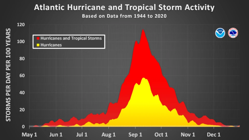
In a typical season, eight named tropical storms and three hurricanes would have formed by this point in September. The contrast with historical norms underscores how dramatically different 2026 has been, with activity concentrated far below seasonal expectations.
Why is the Atlantic so quiet?
The primary driver of this suppressed activity is an exceptionally strong El Niño pattern developing across the tropical Pacific. El Niño, the natural warming of tropical Pacific waters, disrupts weather patterns globally by altering atmospheric circulation. During El Niño events, upper-level winds over the Atlantic intensify, creating increased wind shear—the rapid change of wind speed and direction with altitude. This wind shear tears apart developing thunderstorms before they can organize into tropical storms or hurricanes.
The National Oceanographic and Atmospheric Administration has determined that the current El Niño is on track to be one of the strongest on record, with forecasters expecting it to peak in November or December. NOAA's updated 2026 hurricane outlook continues to call for a below-normal season, with 7–13 named storms, 2–6 hurricanes, and 0–2 major hurricanes anticipated through the end of the season. The agency revised its seasonal forecast in August 2026 and determined there was a 75% chance of below-normal activity, reflecting the suppressing effect of the developing El Niño pattern.

What other factors are keeping storms at bay?
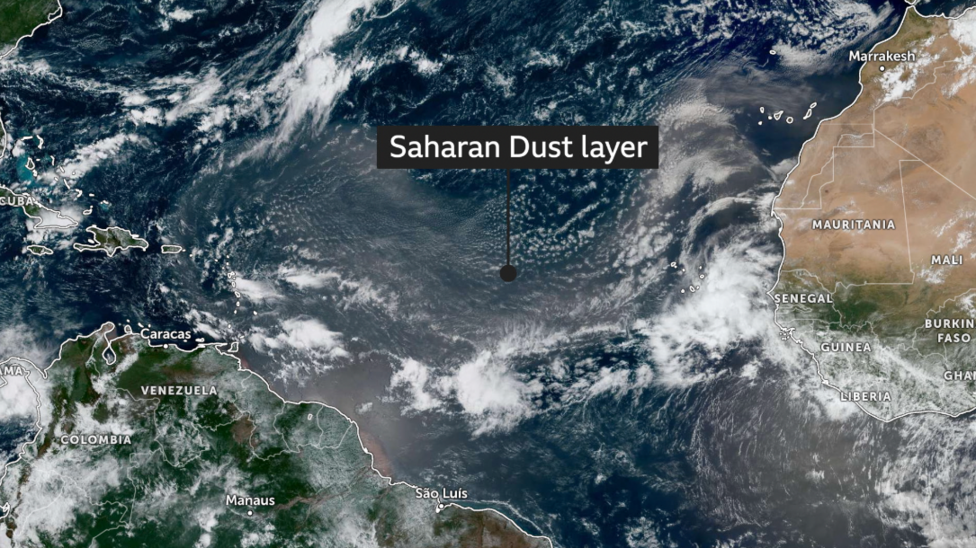
Beyond El Niño, Saharan dust has provided an additional brake on tropical development. Over the past week, dust and sand whipped up by winds in the Sahara have been transported thousands of miles across the Atlantic toward the United States. When this dry, dusty layer of air moves across the ocean, it prevents moisture-laden thunderstorms from developing and organizing. Forecasters expect these dust-laden conditions to persist for at least another week, maintaining suppressed activity in the basin.
How does this compare to the eastern Pacific?
The contrast between the Atlantic and eastern Pacific basins illustrates how El Niño's effects vary by region. While El Niño suppresses Atlantic hurricane activity through increased wind shear, it tends to strengthen conditions in the eastern Pacific. The 2026 eastern Pacific season has been fairly active, with 13 named storms forming to date, including five hurricanes, three of which reached major status. This is close to the number that would typically develop across an entire average season. Major Hurricane Lowell struck Hawaii this week, bringing damaging winds, flooding rain and high waves to the islands.
What were the initial forecasts?
In May, the National Hurricane Center issued a below-average forecast for the 2026 Atlantic season, predicting a total of eight to 14 named storms, three to six of which would become hurricanes, including one to three major hurricanes. This cautious outlook reflected the anticipated suppressing effects of the developing El Niño pattern. The 1991–2020 normal for a complete Atlantic season is 14 named storms, 7 hurricanes, and 3 major hurricanes, making the current forecast substantially below historical averages.
What happens next?
The Atlantic hurricane season continues through 30 November 2026, meaning there remains more than two months for activity to develop. However, forecast coverage on 10 September indicated that a record for the latest first hurricane was within reach if conditions remained suppressed through the middle of September. Forecasters note that the season is still expected to see activity concentrated during the August–September–October peak period, though the strength and frequency of that activity remain uncertain given the persistent El Niño influence.
Key Facts:
- Five named tropical storms have formed in the Atlantic as of 10 September 2026, but zero hurricanes have developed, marking an unprecedented stretch into the season in the satellite era.
- A historic El Niño pattern is expected to peak in November or December 2026 and is on track to be one of the strongest on record, creating increased wind shear that suppresses hurricane formation.
- Saharan dust transported across the Atlantic is providing an additional suppressing effect on tropical development, with conditions expected to persist for at least another week.
- The eastern Pacific has experienced a much more active season, with 13 named storms and five hurricanes, including Major Hurricane Lowell, which impacted Hawaii this week.
- The Atlantic hurricane season runs through 30 November 2026, with forecasters predicting 7–13 named storms, 2–6 hurricanes, and 0–2 major hurricanes for the remainder of the year.


