A Welsh county experienced some of the planet's most intense wildfire-related carbon emissions per square kilometre in July following a series of major fires, according to data released by a children's charity. The Torfaen area, home to the Blaenavon wildfire, ranked fourth globally in wildfire emission intensity that month, behind only Malanje in Angola, Spain's Ávila province, and Annaba in Algeria, based on analysis by Save the Children using European Union earth observation data.
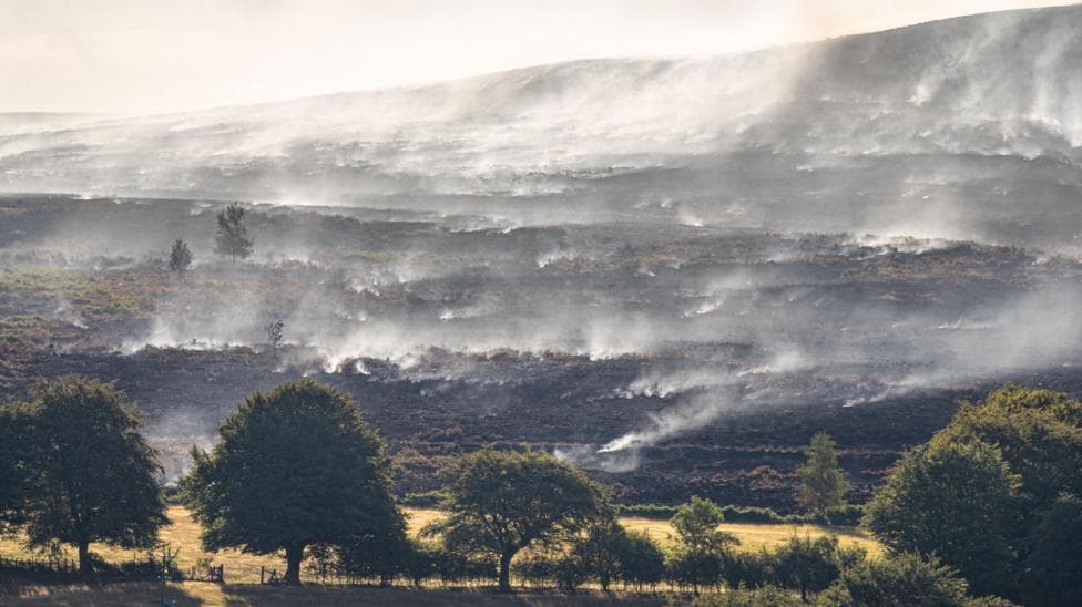
The primary fire ignited on 19 July 2026 on Mynydd Garnclochdy, between Abersychan and Blaenavon, and continued burning for weeks afterward. The initial blaze covered approximately 300 football pitches in area, eventually expanding to more than 200 hectares by 21 July as specialist officers conducted tactical burns and farmers cut fire breaks to contain the spread. The fire perimeter stretched about 5 kilometres, burning through fern, gorse and bracken across commons and pasture land. Smoke from the blaze was detected as far away as Cardiff, 30 miles distant, with residents reporting the smell of burning across that distance.
The South Wales Fire and Rescue Service characterised the incident as
one of the largest and most challengingwildfires in the region in recent years. The scale of the emergency eventually triggered a major incident declaration, which led to military assistance being deployed to support firefighting efforts. A second wildfire in Blaenavon on 11 August 2026 required crews to continue containment work with aerial firefighting support from a helicopter, indicating the broader challenge facing the region throughout the summer.
What did the emissions data reveal?
The Copernicus Atmosphere Monitoring Service, part of the European Union's Space programme, recorded emissions from Torfaen as
extremely unusual. Save the Children used this data to highlight the global significance of the Welsh fires. Melanie Simmonds, head of Save the Children Wales, expressed concern about the health implications:
In Wales and across the world, children are breathing in smoke from wildfires, coping with extreme heat and losing the freedom to play outdoors because the air is no longer safe. These conditions are not only frightening - they carry serious health consequences for children whose bodies and lungs are still developing.

How did local air quality respond?
Torfaen council confirmed that its own air quality monitoring detected
elevated particulate concentrationsduring the wildfire period, though the authority initially stated it was unaware of the EU emissions ranking. The council operates a monitoring station in Croesyceiliog Cwmbran that continuously tracks air quality, though it acknowledged that this station measures general background conditions rather than pollution levels immediately adjacent to the fires.
Blaenavon councillor Janet Jones reported that smoke conditions were
particularly badon 13 August, approximately three weeks after the fire first ignited.
There was great concern about air quality and the impact on elderly people and those suffering with respiratory issues such as emphysema and COPD.Jones indicated she had consulted with GP practice nurses two weeks prior and found no reported increase in respiratory complaints at that time, though she cautioned that
this could change in the months ahead.
The council stated it
recognises that prolonged wildfire incidents have the potential to adversely affect local air quality, particularly through increased levels of smoke and particulate matter, and noted that
it is not clear what data or evidence was used in the assessment to arrive at the reported conclusionregarding the global emissions ranking.
What was the broader context of summer 2026 wildfires?
The Blaenavon fires occurred as part of a wider wildfire crisis affecting western Europe. Emergency workers and soldiers were later reported to be battling a deep-seated peat fire spread across 4,000 hectares above Blaenavon, indicating the scale of the underground burning that persisted long after initial containment. The Blaenavon incident formed part of a sequence of major fires across Wales and England during July and early August, with more than 200 wildfires reported across both nations in a two-week period, prompting broader calls for improved land management practices.
Key Facts
- Torfaen recorded the fourth-highest wildfire carbon emission intensity per square kilometre globally in July 2026, according to Copernicus data
- The primary Blaenavon wildfire began on 19 July 2026 and burned across more than 200 hectares with a 5-kilometre perimeter
- Smoke from the fire was detected 30 miles away in Cardiff, and local air quality monitoring confirmed elevated particulate concentrations
- The incident triggered a major incident declaration and required military assistance alongside firefighting crews
- A second Blaenavon wildfire on 11 August 2026 required continued aerial firefighting support