A large area of low pressure developing over the Atlantic will channel warm south to south-easterly winds into the UK during the early part of this week, though precipitation will follow in its wake. Tuesday is expected to deliver the warmest conditions, after which temperatures will settle back towards typical September levels.
Wetter and windier weather will accompany the approaching depression across much of the country, with the most turbulent conditions forecast for Scotland, Northern Ireland and the western regions of England and Wales. By contrast, central, southern and eastern parts of England—areas that have endured prolonged dry conditions—may receive considerably less rainfall from this system.
The current drought situation underscores the regional disparities in recent weather patterns. According to the Environment Agency's latest assessment, England still has 10 areas classified as being in drought status, with the remainder experiencing prolonged dry weather. The agency's most recent summary indicated that drought status remained unchanged this week despite some recent rainfall, highlighting the severity of the situation.
How will the week's weather unfold?
Monday morning will be notably cold, with fog patches possible in some areas that may affect travel. Once the fog disperses, brighter conditions are anticipated for much of the country, with high pressure supporting sunny intervals and only scattered showers. South-east England may experience some rain during the afternoon and evening, though this is not certain. Temperatures will range from the mid to high teens, with some southern areas potentially reaching 20°C.
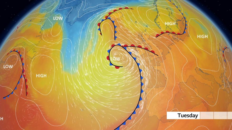
Tuesday will see a strengthening southerly wind delivering significantly warmer air across the country. The Met Office's latest trend analysis suggests temperatures could potentially reach 27°C to 28°C in southern and south-eastern England before conditions deteriorate. Scotland and Northern Ireland will see highs in the high teens, while England and Wales will experience temperatures between 20°C and 26°C.
However, rain will move into Northern Ireland during the afternoon, then gradually track eastwards through the evening and overnight hours. This rainfall may become persistent and occasionally heavy, accompanied by strong winds and gales affecting exposed coasts and hills. Further east, drier and brighter conditions may persist before the rain arrives on Wednesday, potentially lingering into the following morning.
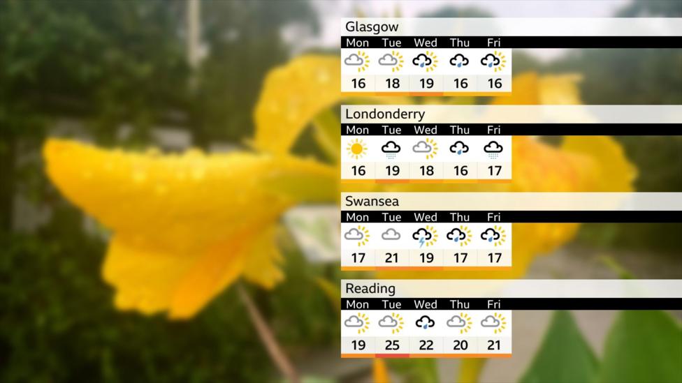
Behind the rain, sunny spells and scattered showers will return, with the west remaining windy on Wednesday. By Thursday, high pressure is expected to build, bringing calmer and drier conditions. Friday will see any remaining showers concentrated in the north-west.

Why has September shown such contrasting weather patterns?
The autumn equinox occurred last week, meaning nights are now longer than days. Despite the warmth from the September sun, cooler nights are developing under clear skies, creating a transition into autumn conditions.
September has continued the trend of notable warmth following the UK's hottest summer on record. However, the month has also revealed a striking north-west to south-east divide in rainfall distribution. While Scotland and other western regions have experienced frequent Atlantic weather systems bringing rain and wind, much of central, southern and eastern England has remained predominantly dry with abundant sunshine.
This contrast has resulted in dramatically varied rainfall totals across the country. Some drought-affected parts of England have received very little precipitation, while parts of north-west Scotland have been exceptionally wet. Locations including Kirkwall and Prestwick have already accumulated nearly one-and-a-half times their average September rainfall. At Achnagart in the Highlands, rain has been recorded on every single day for the past 27 days.
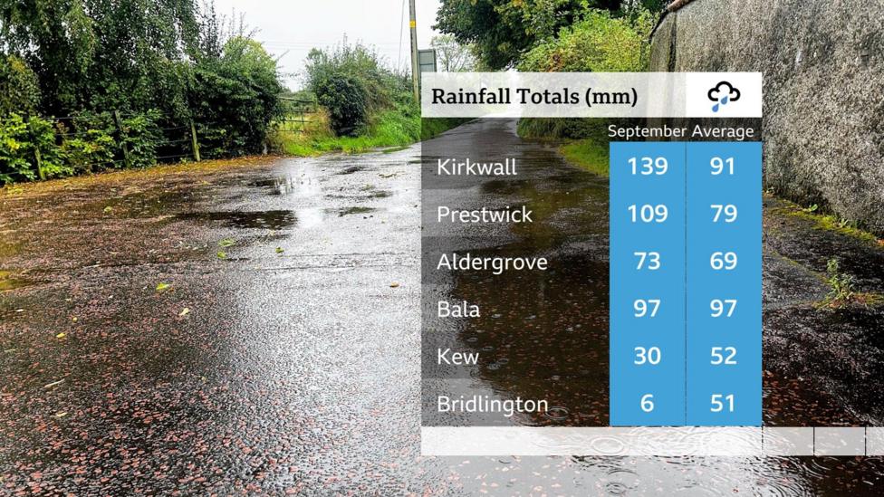
Parts of Northern Ireland and Wales have received their average rainfall, whilst north-east England has experienced some of the lowest amounts so far this month.
What is the broader drought context?
The current drought situation developed following an exceptionally dry spring and summer, alongside a succession of heatwaves. According to government and Environment Agency guidance, around 120% of typical rainfall will be needed between now and April 2027 for all areas to exit drought status. This substantial requirement underscores the depth of the water deficit that has accumulated.
The regional nature of the drought means that while some areas may benefit from the approaching wet spell, others will see limited relief. For drought-affected regions in the south and east, the current forecast suggests this week's rain system will largely pass them by, leaving their water situation largely unchanged.
What happens next?
Following the warm spell and associated rain, conditions are expected to remain changeable into the coming days. According to the Met Office's short-range outlook, wetter and windier weather will become increasingly likely after the initial warmth passes. The Environment Agency's next drought summary is expected following the reporting period ending 24 September, which will provide updated information on whether the week's rainfall has altered the drought status in any regions.
Forecast details remain subject to change, so checking the short-term forecast for your specific area is advisable as the week progresses.