
Temperatures across the United Kingdom could climb to as high as 26C on Tuesday as a strong southerly airflow transports warm air from continental Europe, marking a significant departure from typical late September conditions.
The most pronounced warming will occur in south-east England, where mid-20s temperatures are anticipated. However, across England more broadly, readings will widely exceed 20C, with the high teens expected in Wales, Northern Ireland and Scotland. According to the latest weather forecast, southern and southeastern areas could potentially reach 27C or 28C before conditions shift. This warmth will represent a departure of 3 to 6 degrees above the seasonal norm for this time of year.
The exceptional warmth stems from a large area of low pressure developing in the eastern Atlantic and moving toward Iceland, which is drawing warm southerly winds across the continent. Unusually hot air currently affecting France and Spain—where temperatures have exceeded 30C—will be channelled northward into British airspace by this wind pattern.
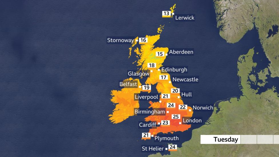
Tuesday morning may begin with considerable cloud cover and scattered showers, but sunny spells are forecast to develop across England and Wales as the day progresses. Northern Ireland and western Scotland will experience strengthening southerly winds, with gusts reaching up to 50mph in these regions. Across Wales, Northern Ireland and Scotland, maximum temperatures on Tuesday will range from 17 to 22C, remaining warmer than average despite being cooler than south-eastern areas.

How warm will overnight temperatures be?
Overnight temperatures will remain unusually elevated, with the warm southerly winds persisting into Wednesday morning. In much of the country, minimum temperatures are expected to fall only to between 15 and 19C—typical of a summer night rather than early autumn. In parts of south-east England, temperatures may not fall below 20C at all, a striking contrast to the late September average of 7 to 11C. This will represent one of the warmest nights of the season for many locations.
What happens after Tuesday?
The exceptional warmth will prove short-lived. According to the Met Office's latest forecast update, wetter and windier conditions are increasingly likely to develop through the following days as the weather pattern shifts. Rain is expected to return to parts of the UK after Tuesday, with temperatures gradually easing back toward seasonal averages. The forecaster has described the late-week warmth as exceptionally warm for the time of year, emphasising that this represents a temporary spike rather than a sustained trend.
How does September 2026 compare to historical norms?
September will mark another month in which average temperatures significantly exceed normal levels. Up to 26 September, the Central England Temperature (CET)—the world's longest-running temperature record tracking average conditions across various English locations—stands 2.6 degrees Celsius above normal. This continues a remarkable pattern: every month of 2026 has recorded average temperatures above the historical baseline, with the year-to-date average also running 2.6C higher than normal.

For 2026 to avoid becoming one of the warmest years on record for the United Kingdom, the remainder of the year would need to experience substantially colder-than-normal conditions. The Met Office's latest three-month outlook for October through December suggests higher-than-normal chances of a mild autumn and early winter, making such a reversal unlikely. This sustained warmth reflects broader climatic patterns affecting the region, with meteorologists noting the sharp temperature contrast between southern and southeastern areas experiencing warm, humid conditions and other parts of the country being less affected by the continental influence.
Key Facts
- South-east England could reach 26C or higher on Tuesday, with temperatures 3–6 degrees above the late September average
- Overnight temperatures may not fall below 20C in parts of south-east England, compared to a typical late September minimum of 7–11C
- Every month of 2026 has recorded above-average temperatures, with the year-to-date average running 2.6C higher than normal
- Wetter and windier weather is forecast to replace the warm spell from Wednesday onward
- The Met Office suggests higher-than-normal chances of a mild autumn and early winter ahead