El Niño Officially Begins, Raising Concerns Over Weather Extremes
El Niño, the natural Pacific weather phenomenon that elevates global temperatures, has officially commenced, according to US scientists.
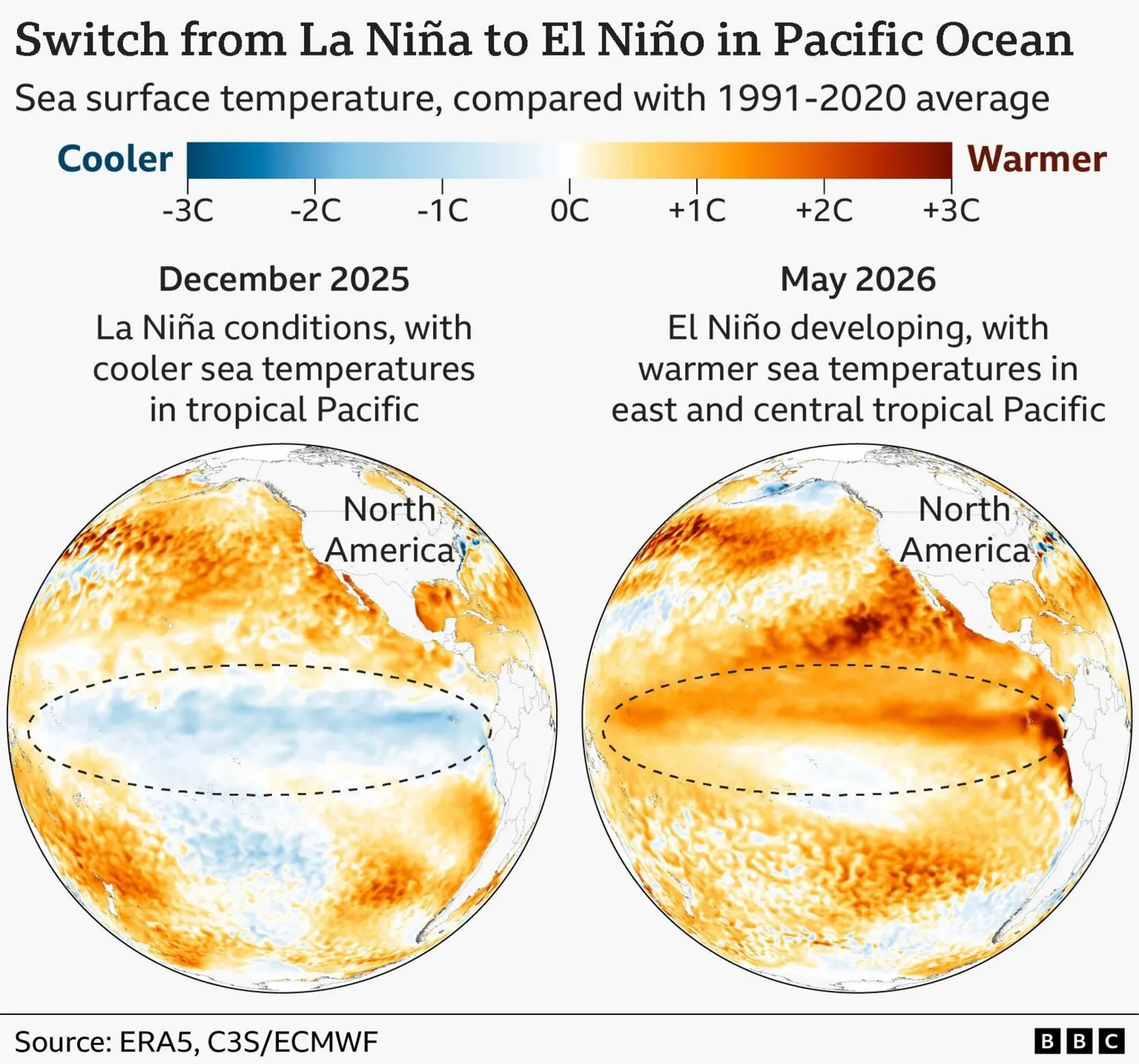
The US National Oceanic and Atmospheric Administration (NOAA) has confirmed that El Niño conditions are now present in the tropical Pacific, marked by a significant rise in sea surface temperatures over recent months.
Forecasts indicate this event could develop into a "super" El Niño, potentially ranking among the strongest ever recorded.
Combined with decades of human-induced warming, this could result in another record-breaking hot year, most likely in 2027, accompanied by disruptions to weather patterns, food supplies, and economies extending well into that year.
This NOAA announcement aligns with expectations, as forecasters anticipated this warming phase following the conclusion of the cooler "sister" pattern, La Niña, at the end of last year.
Sea surface temperatures in the central and tropical Pacific have surpassed the 0.5°C above-average threshold NOAA uses to define an El Niño event.
Additionally, NOAA has observed shifts in winds above the equatorial Pacific, signaling that the atmosphere is responding to the warmer ocean, rather than the ocean warming independently.
What has surprised researchers is the high confidence level of computer models regarding the event's strength.
El Niño's intensity is gauged by the degree to which sea surface temperatures exceed average levels in a critical Pacific zone.
A strong El Niño is classified as more than 1.5°C above average; a very strong event exceeds 2°C.
In its June outlook, NOAA assigned a 63% probability to a very strong El Niño, which it states "would rank among the largest El Niño events in the historical record going back to 1950."
Some recent US and European (ECMWF) models project even higher temperatures, with tropical Pacific sea surface temperatures potentially exceeding 3°C above average by year-end.
The primary concern is that this is occurring on an already significantly warmer planet.
"We do need to worry about the impacts," said Prof Adam Scaife, head of monthly to decadal prediction at the UK Met Office.
"The current El Niño is… riding on top of a substantial amount of global warming.
"This means that the actual temperatures in affected regions could well be unprecedented, as the warming from El Niño is being topped up by climate change."
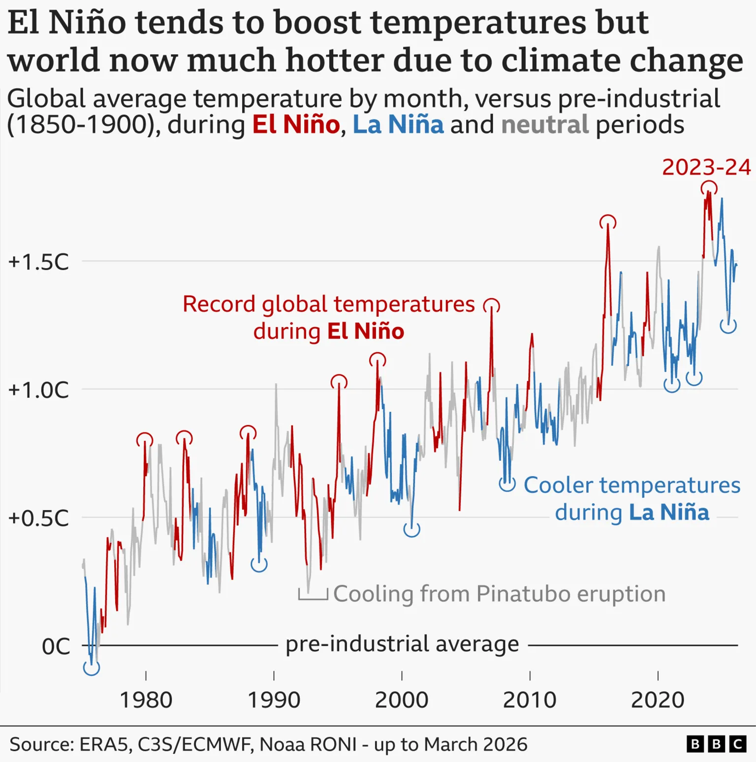
A very strong El Niño typically raises global air temperatures by approximately 0.2°C, releasing heat stored in the ocean into the atmosphere. This additional heat now affects a world already experiencing record temperatures.
The year 2024, the warmest on record, was influenced by an El Niño that was not particularly strong.
Despite the cooling effect of a La Niña event, 2025 ranked as the third warmest year on record, surpassing even the super El Niño year of 2016.
"At the end of this year and into 2027, we're likely to see very high temperatures globally," Prof Scaife said.

"In 2027, we're likely to see excess heat on top of the global warming we've already got, and that could easily lead to another year above 1.5 degrees [of warming above late-19th-Century levels]."
Although no two El Niños are identical, their impacts are most pronounced in tropical regions.
Flooding is common in northern Peru and southern Ecuador and can extend to parts of East Africa, Central Asia, and the southern United States.
Conversely, the risk of drought and wildfires increases across much of Australia, Indonesia, and northern South America, adversely affecting agriculture and global food stocks.
El Niño also tends to suppress Atlantic hurricane activity, with forecasters already predicting a quieter-than-average season.
"While that sounds like a good thing, for Central America that leads to a lot less rainfall and potentially drought conditions," said Liz Stephens, professor of climate risk and resilience at the University of Reading.
Even the UK experiences subtle effects: El Niño can slightly increase the likelihood of a mild start and cold end to winter, although these links are not strong.
For many people, the forecast is far from theoretical.
"An El Niño declaration is not just another weather forecast - for millions of people it is a deadly siren to be feared," said Mohamed Adow, director of campaign group Power Shift Africa.
"It means failed rains, dying crops, rising food prices, and families pushed to the edge yet again. In East Africa especially, this will land on communities already battered by droughts and floods in recent years."
Japan's Meteorological Agency (JMA) concurs with NOAA, confirming El Niño conditions are present and almost certain to persist into autumn.
However, not all agencies have formally declared El Niño. Australia's Bureau of Meteorology (BoM) applies a stricter criterion, requiring sea surface temperatures to exceed 0.8°C above average.
This week, BoM stated the tropical Pacific is "approaching El Niño conditions," with central Pacific temperatures crossing its thresholds, but it has yet to officially declare the event.
BoM anticipates El Niño will develop later this year and could be strong.
El Niño events typically occur every two to seven years and last about a year.
There remains no definitive evidence that climate change is increasing the frequency or strength of these events; however, a warming world can amplify their impacts.
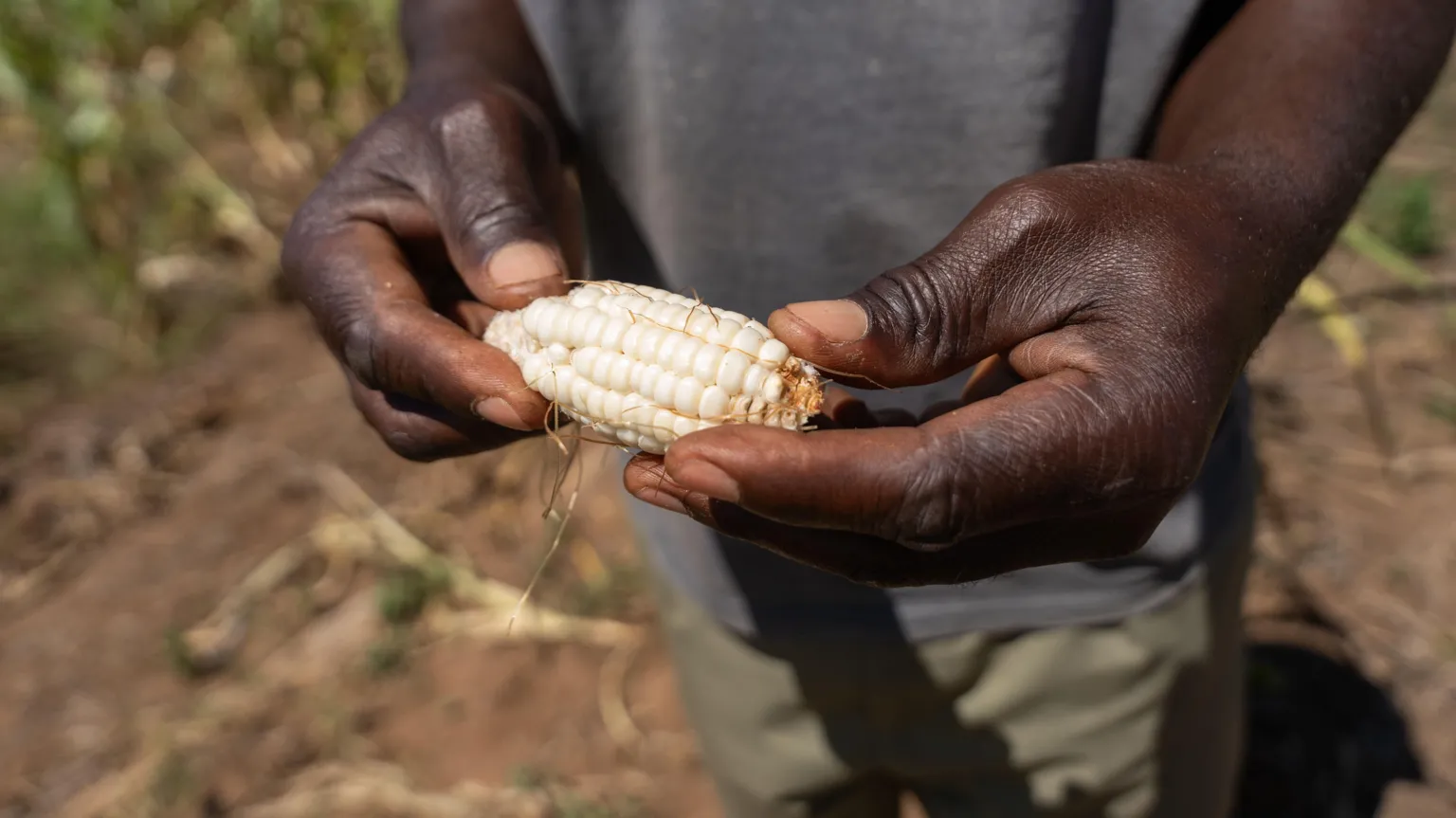
Impacts on Agriculture and Communities
Previous El Niño events have severely impacted agriculture, as illustrated by a farmer in Zambia showing a small ear of corn grown in drought-affected fields.
Staying Informed on Climate Developments
To receive exclusive insights on the latest climate and environmental news from the BBC's Climate Editor Justin Rowlatt, for the Future Earth newsletter, delivered weekly to your inbox.