Coastal Erosion Devastates UK Communities and Infrastructure
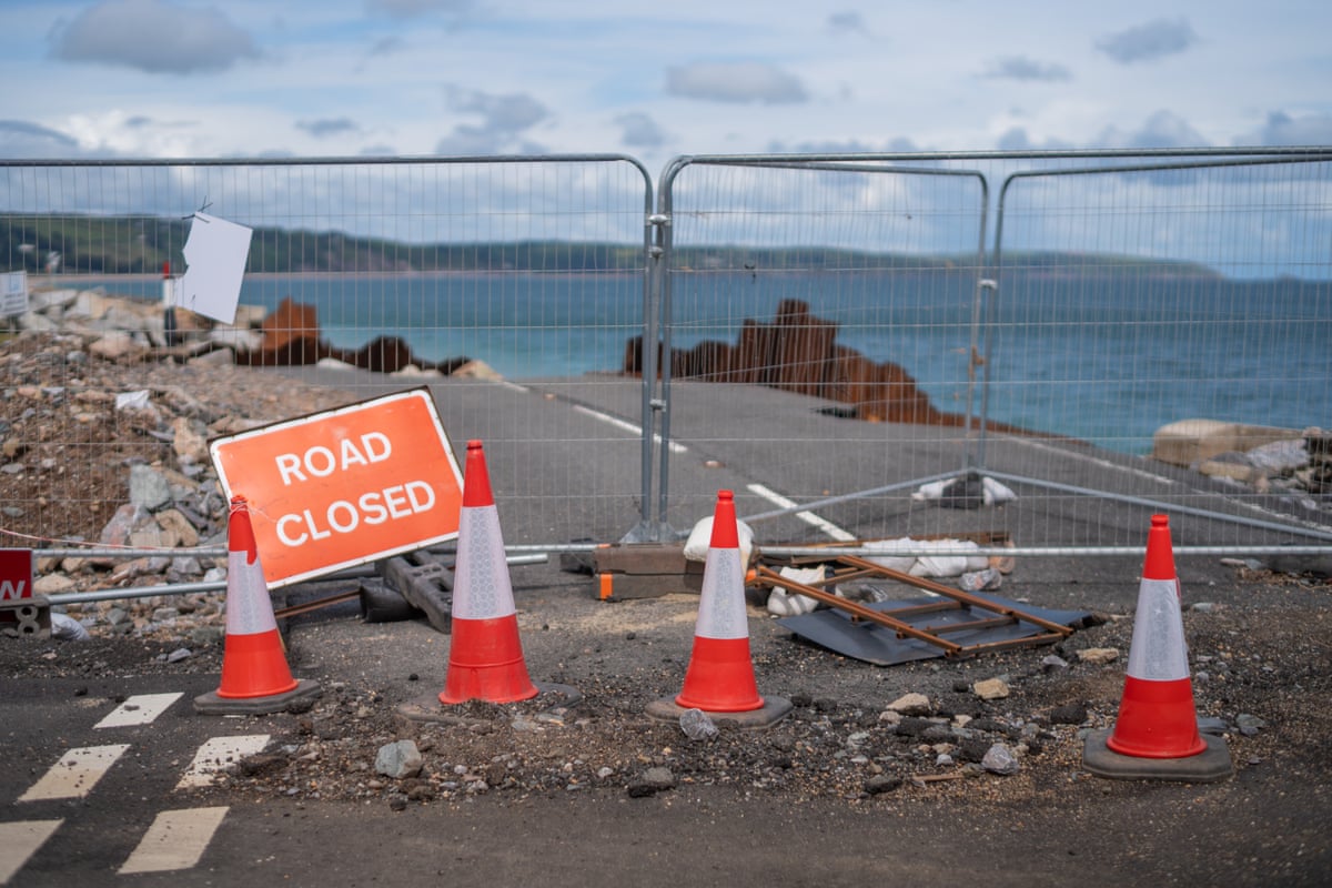
The remains of the road connecting two towns in South Devon lie scattered along the foreshore in a chaotic mix of tarmac, steel, and concrete.
The Slapton Line, a dramatic coastal road bordered by an environmentally protected freshwater lake on one side and the sea on the other, links Kingsbridge and Dartmouth. This year, winter storms destroyed a section of the A road between Torcross and Slapton, an area at the forefront of rising sea levels and coastal erosion. This outcome was predicted over 30 years ago but has not been adequately prepared for.
On bank holiday Monday, hundreds are expected to walk the route as the tourist season begins, drawing attention to how the road's collapse has impacted livelihoods and threatened local lifestyles.
“It is just worrying that nothing is being done,” says Gill Sterry, owner of the Sea View campsite. “I know it takes a long time but its been three months now. Something could have been done to improve the road – even just a little bit of tarmac in places. We feel forgotten about.”
The debris in Devon exemplifies the broader lack of national preparedness to address the inevitable erosion of land beneath coastal communities across the UK.
“No great master plan has slipped into place. There isn’t one,” says Dan Thomas, cabinet member for highways and transportation at Devon County Council, reflecting on the £18 million cost to repair the road, which excludes defensive measures. “£18m out of our whole capital budget for transport of £80m – almost 25% of that budget for a year: that is a sucker punch that the council cannot take.”
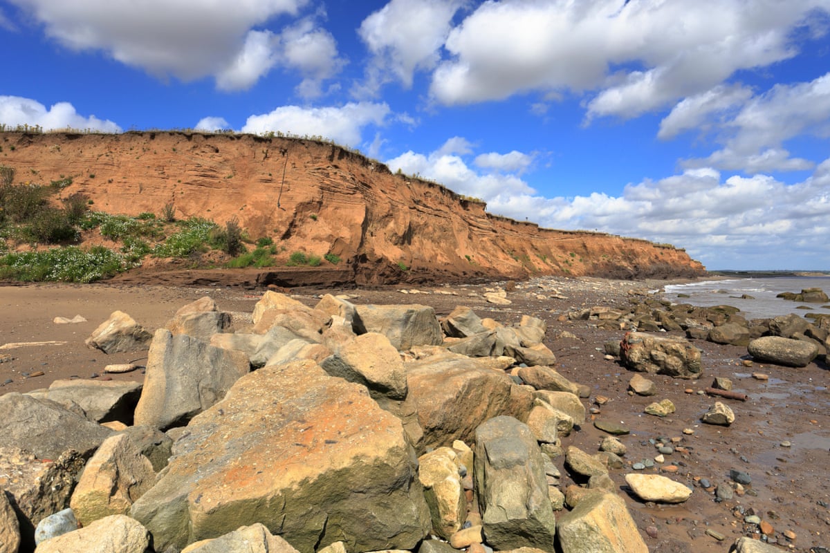
From the East Riding of Yorkshire, where the soft boulder clay cliffs at Holderness retreat up to 4.5 metres annually—among the highest rates in Europe—to the north Norfolk coast, Suffolk, and the Isle of Wight, communities face accelerating coastline retreat driven by the climate crisis.
More than 10,000 properties, with some estimates rising to 20,000, are at risk from coastal erosion over the next 80 years. Additionally, at least 3.7 miles (6 km) of railways and 114 miles of roads are threatened, with the Slapton Line serving as a recent dramatic example.
Efforts have been ongoing for several years to predict the timing and location of worst erosion, but no national adaptation strategy is currently ready for implementation.
Twenty shoreline management plans, developed collaboratively by the Environment Agency, local authorities, and some coastal groups, categorize coastal areas based on risk and the economic and physical viability of protecting homes and businesses. The categories include “hold the line,” which supports upgrading sea defenses such as sea walls; “managed realignment,” which allows the shoreline to retreat naturally but manages the process; and “no active intervention,” which means no new investment in sea defenses.
The government is also funding a £36 million series of pilot projects, extended this year, aimed at helping communities adapt to the reality of their future, leverage enhanced financial support, and come to terms with inevitable changes.
However, no compensation or insurance is currently available for those who lose properties to erosion, and stakeholders involved in pilot schemes emphasize the urgent need for these initiatives to become mainstream national action plans.
Norfolk Faces Significant Home Losses Due to Climate Change
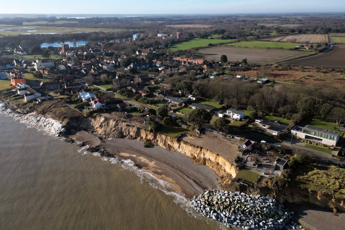
In Norfolk, the climate emergency and rising sea levels threaten 21 miles of soft cliffs, potentially causing the loss of up to 1,600 homes within 80 years.
Sophie Day, senior researcher at the University of East Anglia for the Coastwise pilot project, recently witnessed the demolition of homes in Happisburgh. North Norfolk District Council and Coastwise had supported residents through a prolonged preparation process, offering financial assistance exceeding the current £6,000 grant.
“Together we watched the houses being taken down. We stood there shoulder to shoulder. It felt like a funeral watching their homes go. It was profound to be there.
“It is important to be brave and face up to this massive problem, but it is hard.”
North Norfolk District Council had to maintain secrecy until the final moment to prevent social media users from descending on the community during this sensitive time.
Natasha Dix, an environmental officer from Isle of Wight Council, informed MPs on the Environment, Food and Rural Affairs Committee that when homes are lost, the island attracts disaster tourism, including YouTubers and Instagram users documenting personal tragedies.

“That is while the homes are still moving and collapsing,” she said. “Seeing people’s personal effects, their children’s effects, their children’s play toys being picked through by a YouTuber, who is then happily displaying that all over the internet, is one of the most traumatic things that our community has had to deal with.”
Devon’s Slapton Line and Local Responses
In Devon, Torcross, at one end of the Slapton Line, is designated “hold the line” under the shoreline management plan. The Environment Agency announced this month an upgrade to the sea defenses on the beach, which were also damaged during winter storms. This project has been welcomed by villagers as a vital protective measure.
Caroline Voaden, Liberal Democrat MP for South Devon, has focused on protecting the community and repeatedly raised investment in defenses with the government.
“I hope this funding [for sea defences] is the start of the long road back to normality for this resilient community,” she said.
However, the road itself is classified as “managed realignment.” Ministers have yet to confirm whether they will provide financial support for the £18 million rebuilding of a road that has partially collapsed multiple times before this latest catastrophic failure.
In Yorkshire, 30 miles of the East Riding coast are designated as “no active intervention.” Communities must accept that nothing will be done to slow dramatic coastal erosion, which is expected to accelerate due to the climate crisis. Over 80 years, nearly 5,000 homes (one-third of all homes), 1,550 non-residential properties, and much of the coastal road network are projected to be lost.
“It is a very emotional subject for people and the uncertainty around managing coastal erosion is detrimental to long term economic growth,” says Richard Jackson of Changing Coasts East Riding, one of the pilot projects funded by the Environment Agency’s coastal transition accelerator programme.
Such trauma and emotion are evident wherever the coastline retreats. In Norfolk, Happisburgh has been at the center of a prolonged struggle between a community fighting for survival and a shoreline management policy that increasingly deems continued protection unrealistic and unsustainable.
Originally designated “hold the line,” Happisburgh was reclassified to “managed realignment” 14 years ago. Residents report that this designation causes blight, crashes property values, and renders homes uninsurable.
Sue Stockton, who purchased the Hill House pub in the village before the redesignation, said:
“Twenty years ago, villagers fundraised to buy rocks to put on to the beach. We can’t do that now because of the definition.
“It is insulting to me that instead of putting up defences people come round all the time suggesting things like: ‘Put your pub on wheels and move it inland.’ This is a 400-year-old building – it is impossible for me to move it.”
Just 11 miles up the coast, innovative solutions have been implemented to protect the Bacton gas terminal, which supplies a third of UK gas, and nearby villages. Engineers used sandscaping, a technique previously applied in the Netherlands, to defend the utility and communities.
Dutch engineer Jaap Flikweert from Haskoning led the project, drawing on experience from the Netherlands, which faces significant long-term threats from the North Sea.
“Traditional solutions would have been putting rock or concrete down against the cliffs, but if you did that it would make the situation worse for the villages.
“So we came together to tackle a problem that was unsolvable by traditional means. We put a Wembley Stadium’s worth of sand on to the beach to create a bulge to protect the gas works. It has improved the beach and given the 200 or so homes in Bacton and Walcott 10 to 15 years of breathing space to adapt and transition.
“But in the long term, these villages are in a really difficult place.”
Preparing for Inevitable Infrastructure Loss
With the collapse of the A379 in Slapton in mind, Coastwise is developing initiatives to prepare for the likely severing of the coast road in Trimingham.
Day commented:
“Some would say that the erosion of the A379 has been foreseeable for decades, and questions should be asked about whether it is possible to keep patching up this road and others like it.
“In North Norfolk, Devon and elsewhere, what we need is longer-term policy and options to support conversations around the loss of coast roads at risk and how to plan for … much more resilient outcomes. Sadly, to try and maintain a business-as-usual approach effectively feels like throwing money into the sea.”
For communities around Torcross and Slapton, no preparations have been made for the permanent loss of such significant infrastructure, nor has there been discussion about the potential need for parts of the community to relocate.
Helen Millman, a glaciologist from Exeter University who grew up locally, said:
“Moving people away from areas like these takes decades of planning – you cannot just move people overnight. Everyone has to be warned, mortgages are 25 years long – these things need to be prepared for.”
A Defra spokesperson stated:
“This government is determined to support coastal communities in adapting to the impacts of climate change. We have already invested more than £600m over the last two years in protecting communities from sea and tidal flooding and we have also allocated £30m for coastal communities adapting to eroding shores.”