

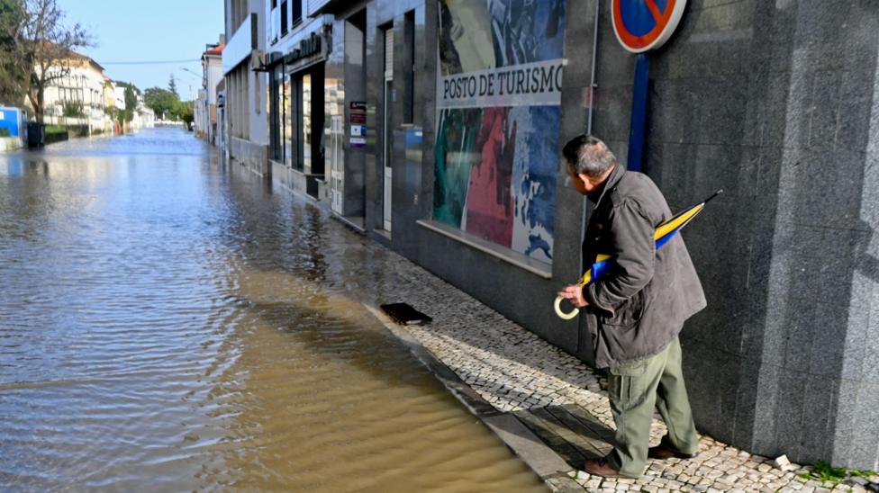
State of Emergency Extended in Portugal Amid Ongoing Rainfall
A state of emergency has been extended in Portugal as persistent rainfall continues to affect the region.
Hundreds of thousands of people have been evacuated across Spain, Portugal, and Morocco following widespread flooding caused by Storm Leonardo.
Emergency services and military personnel have been actively involved in rescuing residents from their homes, with authorities urging those who remain to evacuate immediately.
The Portuguese government has extended the state of emergency, describing the situation as a
"devastating crisis"triggered by a series of storms.
Storm Marta is expected to arrive on Saturday, bringing additional rainfall to the affected areas.
Meanwhile, other parts of Europe are experiencing extremely cold conditions.
These events are linked to a persistent weather pattern that has remained unchanged for several weeks.
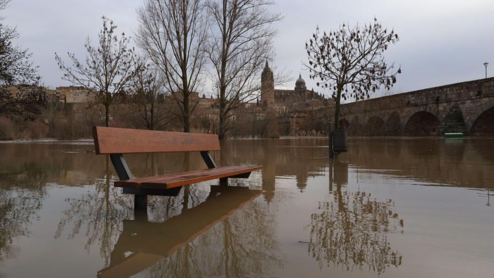
Severe Impact on Iberia from Continuous Wet and Windy Weather
The Iberian Peninsula has been severely affected by wet and windy weather since the start of the year.
In 2026, six major low-pressure systems have impacted the region, with Storm Leonardo being the most recent.
This storm brought exceptionally heavy rainfall to the Algarve region in Portugal and Andalucia in Spain. In Andalucia, approximately 3,500 people have been evacuated as river levels reached record highs.
More than 100 roads have been closed due to flooding, landslides, or fallen trees, and some high-speed rail services have been suspended.
Grazalema, a mountainous area in Andalucia, recorded 672mm (26.4 inches) of rain over a day and a half, nearly matching London's annual rainfall.
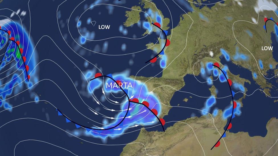
Storm Marta Named as Next Weather System to Affect South-West Europe
Storm Marta, the latest in a series of storms to impact south-west Europe this year, is forecast to arrive over the weekend.
The Portuguese weather service has named the storm, which is expected to bring strong winds, heavy rain, and mountain snow on Saturday.
The Algarve and Andalucia regions could receive up to 50mm (2 inches) of rain. Although this is less intense than previous rainfall, it is unlikely to alleviate the current flooding situation.
Wind gusts of 60mph (100km/h) or more are anticipated across Iberia, with 10-meter waves expected along Portugal's west coast.
The storm is projected to push rain eastwards across the Mediterranean early next week, maintaining unsettled weather conditions.

Evacuations and Flooding in North-West Africa
In north-west Morocco, the town of Ksar El Kebir is largely deserted following the Loukkos River bursting its banks last week.
Tunisia experienced its heaviest rainfall in over 70 years during January, accompanied by severe weather and flooding in Algeria.
Morocco has been particularly affected in recent weeks. The port of Tangier recorded approximately four times its average January rainfall last month, with additional heavy rain impacting northern areas on Wednesday in connection with Storm Leonardo.
The military has been deployed to assist with evacuations amid a red alert for further heavy rainfall this week. Over 140,000 people in northern Morocco have already been evacuated.
Authorities have urged residents in flood-prone areas of the country's north-western plains to evacuate immediately due to increasing risks from heavy rain, swollen rivers, and controlled releases from full dams.
Storm Marta is expected to bring more rain to northern Morocco and Algeria this weekend.
The exceptional rainfall has ended a seven-year drought in Morocco, which had previously accelerated investments in desalination projects.

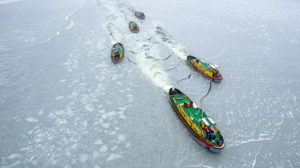
Extreme Cold Conditions in North-East Europe
In contrast to the wet conditions in southern and western Europe, Scandinavia and regions around the Baltic Sea have experienced exceptionally cold weather.
Lithuania recorded temperatures as low as -34.3C (-29.7F) on Monday morning, marking the lowest temperature in the country since 1996.
While cold weather is typical for Lapland at this time of year, parts of northern Sweden have experienced their second coldest January on record.
The persistent cold has extended into Ukraine, where temperatures in Kyiv have dropped to -20C (-4F). The temperature has risen above freezing on only six days so far this year.
Weather Pattern Responsible for Ongoing Conditions and Outlook
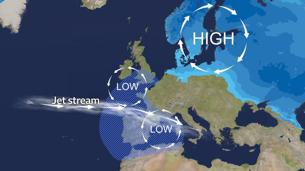
The extreme weather affecting Europe and north-west Africa is primarily due to a persistent high-pressure system stationed over Scandinavia since the beginning of the year, which is responsible for the cold conditions.
This high-pressure system has blocked low-pressure areas and milder, wetter weather from the Atlantic, deflecting the jet stream further south. This has resulted in wet conditions in the UK, western Europe, and the Mediterranean region.
The typical weather pattern observed over recent weeks, showing cold air and areas of heaviest rainfall, is expected to continue into next week.
Cold, blocking high-pressure systems are notoriously difficult to dislodge during this time of year. North-east Europe is likely to remain very cold throughout much of February, with stronger winds increasing wind-chill effects.
Some of this cold air may move towards the UK later next week, increasing the risk of frost, ice, and snow.
Low-pressure systems will continue to bring wet and windy weather to central and southern Europe, raising the risk of flooding, damage, and disruption from strong winds.
For southern Iberia and north-west Africa, there may be some relief as high-pressure areas could build from the Canary Islands at times. Any rainfall in the next two weeks is expected to be less widespread and less intense. Following Storm Marta, no new named storms are anticipated for at least one to two weeks.


