UK Winter Rainfall Above Average but No National Records Set
If you have experienced persistent rain and flooding this winter, you might expect that weather records have been broken. However, provisional data from the Met Office indicates that rainfall this season is approximately 9% above the UK average, indicating a wet winter but not the wettest on record.
These national figures conceal significant regional differences. Certain counties in southern England are on track for their second-wettest winter since records began, while much of north-west Scotland has been considerably drier than usual. This disparity is largely due to a blocked weather pattern that caused repeated rainfall in some areas while leaving others relatively dry.
Relentless Rainfall for Some Regions
The meteorological winter extends until the end of February, leaving a few days of potential additional rainfall. As of 25 February, the Met Office reports that southern England has experienced its seventh-wettest winter since records commenced in 1836. This ranking may change with further rainfall expected before the season concludes.
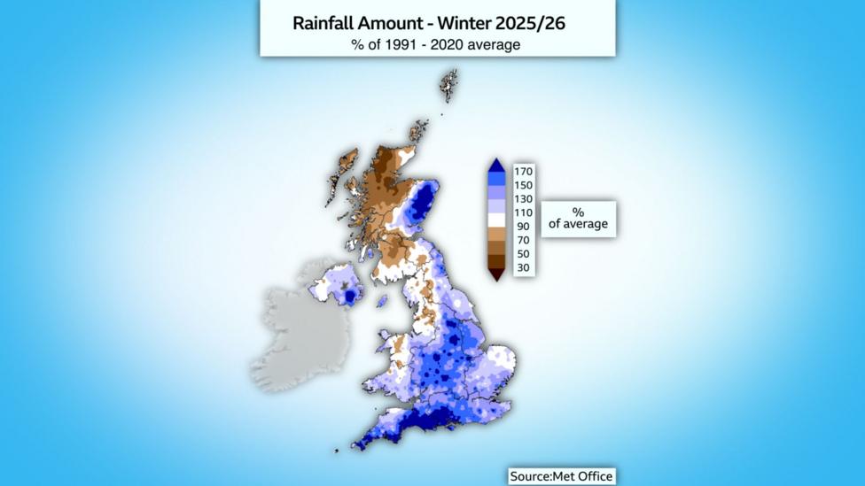
Blue areas on rainfall maps indicate above-average precipitation, while brown areas denote below-average levels.
England overall has received 35% more rainfall than typical for winter, Northern Ireland 25% more, and Wales 14% above average. Conversely, Scotland has experienced 16% less rainfall than normal, despite some eastern regions being notably wet.
These rainfall variations are attributed to a blocked weather pattern that dominated January and February. The jet stream directed low-pressure systems from the Atlantic, but their movement was impeded by a slow-moving high-pressure system over Scandinavia.
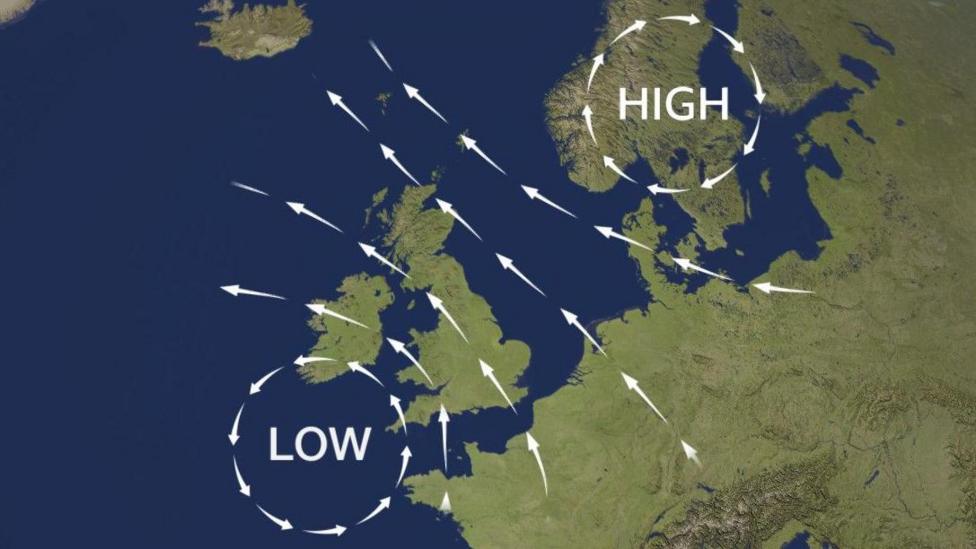
This pattern maintained south-easterly winds over the UK, resulting in persistent rain in exposed areas such as southern England and eastern Scotland, while sheltered regions like western Scotland and north-west England remained drier than usual.
Consequently, some locations endured prolonged rainfall, including Cardinham in Cornwall, which recorded 55 consecutive wet days, whereas other areas experienced relatively dry conditions.
Four Named Storms Impact the UK
Winter saw four named storms: Bram, Goretti, Ingrid, and Chandra.
Storm Bram caused widespread effects but was characterized by the Met Office as a "notable but not exceptional Atlantic winter storm."
Storm Goretti had a more significant impact, particularly in the far south-west of England. It was among the most severe storms to affect Cornwall and the Isles of Scilly in decades. A rare Met Office red warning was issued, triggering emergency alerts to thousands of mobile phones.
A wind gust of 99 mph (159 km/h) recorded at St Mary's was the highest in the Isles of Scilly in 47 years.

Julie Luscombe from Redruth, Cornwall, told BBC Your Voice, "Almost immediately it went from silence to all my fences being taken down. The tiles and the bathroom roof were literally lifting up and slamming back down - it was just so quick."
She added, "I felt disbelief that a storm could have caused so much damage, especially when the trees were ripped out of the ground."
Harry Williams, in Sennen, Cornwall, said, "I'm used to a storm or two but I would say that was the worst I've seen in 30 years. There was an hour where I was apprehensive, and I'm a surfer so I'm used to putting myself in danger."
Heavy rainfall during the storm caused flooding in parts of southern England. Significant snowfall affected Wales, the Midlands, and northern England as the storm encountered cold air.
Storms Ingrid and Chandra struck the south and south-west of the UK within less than a week, exacerbating flooding issues and disrupting road and rail transport.
Limited Sunshine and Snowfall in Some Areas
Sunshine was scarce, notably in Aberdeen, which experienced three weeks of grey skies during what is likely Scotland's fifth dullest winter since 1910.
Some southern UK locations saw slightly more sunshine, but overall the UK received only 80% of the average winter sunshine.
Temperatures were generally above average, although colder intervals occurred, and some areas experienced significant snowfall. Scottish ski resorts reported their best season in years, illustrating that despite overall warming, short cold spells still occur.
Climate Change and UK Winter Trends
UK winters have become warmer and wetter due to human-induced climate change. The Met Office notes that winters have warmed by approximately 1°C (1.8°F) since the 1950s.
Six of the ten warmest winters on record have occurred since 2000, with only one 21st-century winter (2009/2010) among the ten coldest.
This warming has led to fewer frosts and less snow, with about four weeks less ground frost annually compared to 50 years ago.
Conversely, rainfall has increased. Of nearly 260 years of records, six of the ten wettest winter half-years (October to March) have occurred since 2000.
These trends are expected to continue with ongoing global warming. If greenhouse gas emissions remain high, the Met Office projects winters could be 1 to 4.5°C (1.8 to 8.1°F) warmer than in 1990 and up to 30% wetter.
This is because a warmer atmosphere holds more moisture, resulting in heavier and more intense rainfall events.
Get in Touch
Send us your spring photographs and share your most significant weather experiences from this winter.