
Unseasonably Warm Weather Across the UK
On Wednesday afternoon, temperatures soared with Northolt, London, recording 25.5C. This surpassed the previous warmest day of the year, which was 24.8C (76.7F) recorded on Tuesday at Mona on Anglesey, Wales.
Across England and Wales, temperatures ranged in the high teens to low twenties, accompanied by sunny skies and very high pollen levels. However, this warm spell is expected to be short-lived as cooler conditions are forecast to arrive on Thursday.
Uncommonly Warm for Early April
Prior to Wednesday, all four nations of the UK had recorded their highest temperatures of the year on Tuesday, due to warm air drawn in from continental Europe. The foehn effect—a warming wind on the leeside of a mountain—contributed to north-west Wales experiencing the highest temperatures.
- Wales - 24.8C (76.7F) at Mona, Isle of Anglesey
- England - 22.5C (72.5F) at Merryfield, Somerset
- Scotland - 22.5C (72.5F) at Kinloss, Moray
- Northern Ireland - 19.0C (66.2F) at Armagh, County Armagh
On Wednesday, the highest temperatures are expected in the Midlands, East Anglia, and south-east England, potentially reaching 26C (79F) in localized areas. This is approximately 10C above the average for early April.
The last time the UK recorded 25C or more was on 19 September 2025, when temperatures peaked at 27.8C at St James's Park, London. In April, 25C was recorded around this time in 2017 and 2020, but last year this temperature was not reached until the final day of the month.
The highest temperature ever recorded in the UK during April was 29.4C (84.9F), measured in London in 1949. While this record remains unchallenged, spring is currently the fastest warming season due to climate change.
Scotland and Northern Ireland will experience cooler conditions. Cloud cover will break to allow some sunshine, with temperatures reaching as high as 18C (64F) in eastern Scotland.
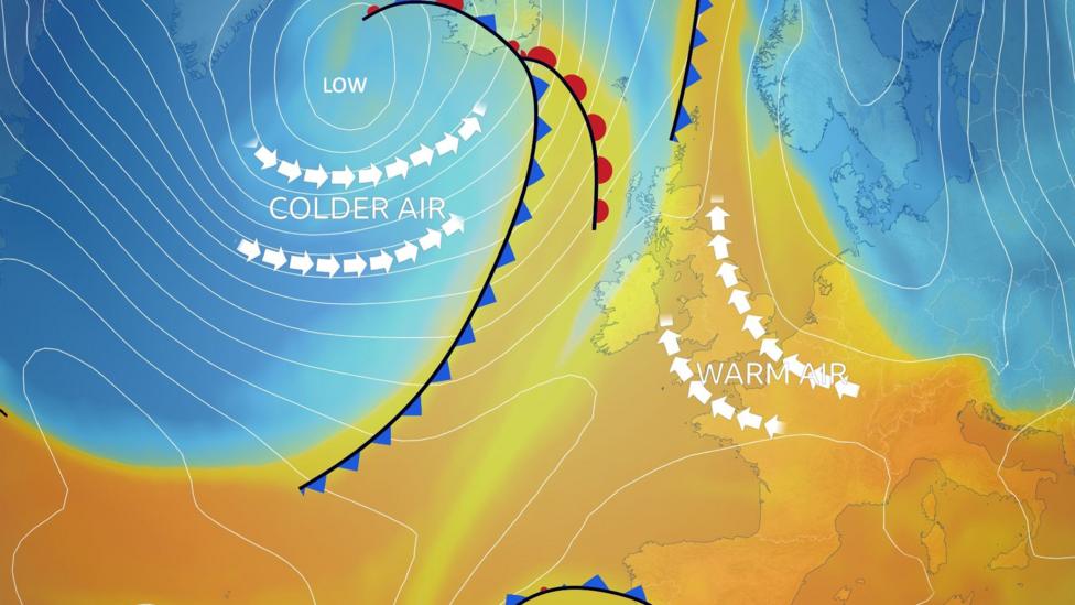
Cooler Weather Expected Later This Week
The weather pattern will shift significantly on Thursday, leading to lower temperatures. A band of rain will move southeastwards across the entire country, followed by sunshine and showers accompanied by a north-westerly wind.
This change in wind direction will bring much cooler air, causing temperatures to drop noticeably to around 10 to 14C (50-57F) across most areas. However, prior to the rain, temperatures in East Anglia and south-east England could still reach 20C (68F).
On Friday, high pressure will return, bringing dry weather and sunshine back to England and Wales, with temperatures ranging from 12 to 15C (54-59F). Meanwhile, western Scotland and Northern Ireland will experience cloud, rain, and stronger winds, signaling a shift to a more changeable weather pattern.
You can keep up to date with the longer range forecast here.

Very High Pollen Levels
With increased sunshine and higher temperatures, pollen levels have risen significantly. In England and Wales, pollen levels remain very high on Wednesday and are still high in parts of Scotland and Northern Ireland.
At this time of year, tree pollen—particularly birch—is the primary cause of hay fever symptoms. Tree pollen affects 25-35% of hay fever sufferers and typically persists from March through early June for most tree species.
Following the weather change, pollen levels are expected to decrease in Scotland and Northern Ireland on Thursday but will remain high or very high in England and Wales.


