
Updated Weather Warnings Issued Ahead of Storm Dave
The Met Office has issued updated yellow weather warnings for wind, rain, and snow in anticipation of Storm Dave's arrival.
A deep low-pressure system is forecast to move across the north-west of the UK on Saturday night, bringing severe gales, flooding, and blizzards.
Potential impacts include travel disruption, power outages, and property damage.
The Easter weekend weather will be variable, with snow in some regions and warm sunshine in others.
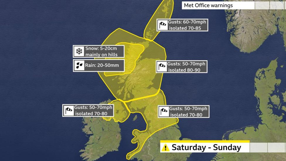
Multiple Weather Warnings in Effect
Northern and western parts of the UK are expected to experience the strongest winds. The Met Office has issued yellow warnings covering Scotland, Northern Ireland, northern England, and parts of north and west Wales.
These warnings apply at different times on Saturday afternoon, overnight, and into Sunday.
Widespread gusts of 50-60 mph (80-97 km/h) are anticipated, with gusts reaching 70-80 mph (113-129 km/h) in exposed coastal areas.
Central and northern Scotland may experience peak winds up to 90 mph (144 km/h).
There is a risk of significant travel disruption during what is expected to be the busiest Easter weekend for drivers in four years.
Bridges may close, ferry services could be cancelled, and delays to planes, trains, and buses are possible.
Rough seas and large waves will create hazardous conditions along the coasts.
Parts of north-west Scotland are also under a Met Office yellow warning for rain and snow.
At lower elevations, particularly in the Western Isles and Skye, up to 50 mm (2 in) of rain could fall, raising the potential for flooding.
Hills and mountains above 200 m (650 ft) are likely to see snow accumulation of 5-10 cm (2-4 in), with isolated areas possibly receiving up to 20 cm (8 in).
Combined with strong winds, these conditions may cause blizzards, snowdrifts, and very poor visibility on roads.
The centre of Storm Dave is expected to pass across the north of Scotland
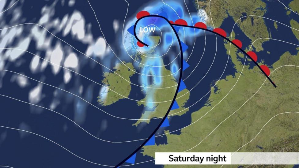
Storm Dave is being driven toward the UK by a powerful jet stream, a high-altitude wind flow that shapes weather systems globally.
This jet stream has been intensified by significant temperature contrasts across the US and Canada in recent days.
Storm names 2025-26: How do storms like Dave get their names?
A Varied Easter Weekend Forecast
Storm Dave is part of a broader weather pattern that will produce diverse conditions across the UK during the remainder of the long weekend.
Skies will clear on Good Friday night, though some showers may persist.
Parts of Scotland, Northern Ireland, and northern England could experience temperatures below freezing, leading to a frosty start on Saturday morning.
Cloud cover will spread northwards on Saturday, bringing rain to northern and western areas, with snow developing over some Scottish mountains.
Central, southern, and eastern England are expected to remain largely dry with occasional sunshine.
Temperatures will range from 7°C (45°F) in northern Scotland to 17°C (63°F) in eastern England.
Winds will strengthen throughout the day ahead of Storm Dave's arrival.
Sunshine and Snow on Easter Sunday
Easter Sunday will feature contrasting weather as the storm gradually weakens.
Strong winds will persist across Scotland, Northern Ireland, and northern England, resulting in a chilly atmosphere with frequent showers.
Some showers may be wintry over hills and mountains, and possibly at low levels in northern Scotland temporarily.
Further south, showers will be less frequent, with parts of Wales and southern England remaining mostly dry and bright.
UV levels are expected to reach moderate in the sunniest locations.
Temperatures on Easter Sunday will range from 7°C (45°F) in northern Scotland to 13°C (55°F) in south-east England.
As winds ease on Sunday night, widespread frost is expected.
Following a cold start on Monday, temperatures will rise during the day, with southerly winds bringing afternoon highs between 10-16°C (50-61°F).
Most areas will experience dry conditions with patchy cloud and sunny spells, contributing to high or very high pollen levels.
Check the Met Office pollen forecast for your area below. Levels range from L for Low to VH for Very High.
Tuesday is currently forecast to be warmer, with temperatures possibly reaching 20°C (68°F) in parts of England and Wales.
Beyond Tuesday, forecast uncertainty increases, but many weather models suggest a return to cooler, more unsettled conditions with April showers and the risk of further strong winds.
You can stay informed about longer-range forecasts with the monthly outlook and follow hour-by-hour updates for your area via the BBC Weather app.
Additional Weather Stories
- Spectacular Pink Moon lights up UK night sky
- Man dies in storm as Saharan dust shrouds Crete
- Carol Kirkwood: Why the time is right for me to retire - and what's next


