

Severe Tropical Cyclone Mitchell Approaches Pilbara Coast
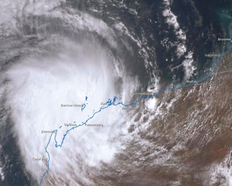
Severe Tropical Cyclone Mitchell is forecast to maintain its category 3 intensity as it moves along the Pilbara coast, with landfall expected between Exmouth and Onslow late Sunday evening or early Monday morning. The cyclone, located west of Karratha, was approximately 30km offshore on Sunday morning, exhibiting sustained winds near the centre of 120km/h and gusts reaching up to 165km/h, according to the Bureau of Meteorology’s latest tracking data.
“The expectation is that it will maintain its category 3 intensity as it moves south-west today, parallel to the Pilbara coast,”said senior meteorologist Miriam Bradbury.
“Although the cyclone could intensify or even slow down slightly as it continues south-west over water.”
Warnings and Expected Impact Along the Coast
A warning zone has been declared extending from Karratha to Cape Cuvier, just north of Carnarvon. This area is considered most at risk for gale-force or damaging winds, with the potential for very destructive wind gusts up to 195km/h as the cyclone’s core nears the coast. EmergencyWA has issued cyclone emergency warnings covering the region from Whim Creek to Onslow, urging residents to remain indoors and take necessary precautions.

Recent observations include wind gusts of 169km/h recorded at Legendre Island at 7pm on Saturday, and 148km/h at Barrow Island on Sunday morning. Bradbury noted,
“It’s mostly the islands that are being caught at the moment, but we’ve still had 90–100km/h wind gusts on that coastal fringe too at places like Port Hedland and Karratha.”
Rainfall and Flood Risks
Widespread moderate to heavy rainfall is expected along the west Pilbara coast, with the possibility of flash flooding and abnormally high tides. These conditions are anticipated to extend into the Gascoyne region by Monday. Karratha has already recorded 67mm of rain since midnight.
Bradbury explained the potential consequences,
“The rain comes in, our rivers start rising, and we’re likely to see impacts for roads, access routes, impacts for communities through those areas too.”
Broader Weather Effects Across Australia
Moisture from the tropics, including from Tropical Cyclone Mitchell, is contributing to the risk of severe thunderstorms across central and south-eastern Australia. This includes parts of New South Wales, Victoria, Tasmania, and inland South Australia. Bradbury highlighted the significance of this,
“That was significant, because storms could bring rain to some very dry parts of the country.”
Tropical Cyclone Season Context
On average, Australia experiences several tropical cyclones annually, with 3 to 4 typically making landfall. This season, Mitchell follows tropical cyclones such as Koji and Luana in crossing the coast. While fewer tropical cyclones are anticipated due to a warming climate, the proportion of severe events is expected to increase, according to meteorological authorities.


